Chambois facts for kids
Quick facts for kids
Chambois
|
||
|---|---|---|

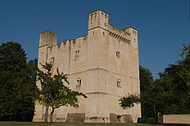
The stone donjon at Chambois
|
||
|
||
| Country | France | |
| Region | Normandy | |
| Department | Orne | |
| Arrondissement | Argentan | |
| Canton | Trun | |
| Intercommunality | Pays d'Exmes | |
| Area
1
|
8.3 km2 (3.2 sq mi) | |
| Population
(1999)
|
475 | |
| • Density | 57.2/km2 (148.2/sq mi) | |
| Time zone | UTC+01:00 (CET) | |
| • Summer (DST) | UTC+02:00 (CEST) | |
| INSEE/Postal code |
61083 /61160
|
|
| Elevation | 89–156 m (292–512 ft) (avg. 110 m or 360 ft) |
|
| 1 French Land Register data, which excludes lakes, ponds, glaciers > 1 km2 (0.386 sq mi or 247 acres) and river estuaries. | ||
Chambois is a small town, also called a commune, located in the northwest part of France. It's found in a region called the Orne department.
Contents
Discovering Chambois
Chambois is best known for its historic castle keep, which is like the main tower of a medieval castle. It's a place with a lot of history!
The Historic Castle Keep
The main attraction in Chambois is its impressive donjon, also known as a castle keep. A donjon is the strongest and most important tower in a castle. It was often where the lord of the castle lived.
This keep is located on the road that connects the towns of Exmes and Falaise. It was built a long time ago, in the second half of the 12th century. A powerful person named William de Mandeville ordered its construction. He was a vassal, or loyal follower, of King Henry II of England, also known as Henri Plantagenêt.
What was the Keep like?
The Chambois keep is a tall, rectangular building, standing about 26 meters (about 85 feet) high. Imagine a building as tall as an eight-story building!
It had special features to make it strong and comfortable. There was an extension on one corner and smaller rectangular towers, called turrets, at each corner. These turrets added to its defenses and also provided extra space.
Inside, the main part of the keep had three levels of rooms. Each room was designed for living, with windows to let in light and a chimney for warmth. The turrets at the corners held smaller rooms or annexes, which might have been used for storage or private spaces. These details show that the keep was not just a fortress, but also a home for its owner.
Related pages
See also
 In Spanish: Chambois para niños
 | Tommie Smith |
 | Simone Manuel |
 | Shani Davis |
 | Simone Biles |
 | Alice Coachman |


