Champoeg Creek facts for kids
Quick facts for kids Champoeg Creek |
|
|---|---|

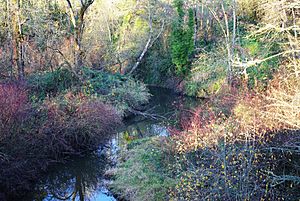
The creek near Champoeg Road, looking north
|
|
|
Location of the mouth of Champoeg Creek in Oregon
|
|
| Country | United States |
| State | Oregon |
| County | Marion County |
| Physical characteristics | |
| Main source | French Prairie 121 ft (37 m) 45°11′02″N 122°55′49″W / 45.18389°N 122.93028°W |
| River mouth | Willamette River near Champoeg 62 ft (19 m) 45°15′14″N 122°52′56″W / 45.25389°N 122.88222°W |
| Length | 6 mi (9.7 km) |
Champoeg Creek is a small river, about 6 miles (10 kilometers) long, in the state of Oregon, USA. It flows into the Willamette River, which is a much larger river. You can find Champoeg Creek entirely within Marion County.
The name "Champoeg" comes from an old language called Kalapuyan. It might be a shorter way of saying a word that means a type of edible root, like a wild carrot, called yampa.
About Champoeg Creek
Champoeg Creek is a "tributary," which means it's a smaller stream that flows into a bigger one. In this case, it flows into the Willamette River. The creek starts in an area called French Prairie, which is part of the Willamette Valley.
The creek generally flows towards the northeast. It joins the Willamette River about 45 miles (72 kilometers) before the Willamette River meets the Columbia River.
Where Champoeg Creek Starts and Flows
Champoeg Creek actually begins when two smaller streams, called East Fork Champoeg Creek and West Fork Champoeg Creek, join together. The East Fork is about 5 miles (8 kilometers) long, and the West Fork is about 6 miles (10 kilometers) long.
Soon after it starts, Champoeg Creek flows into two reservoirs: McKay Reservoir and then Spada Reservoir. A reservoir is like a big lake where water is stored. The creek also passes under a road called St. Paul Highway Northeast.
Other Streams Joining In
As Champoeg Creek continues its journey, other smaller streams flow into it. First, Murphy Creek joins from the left side. Then, the creek goes under McKay Road Northeast and Champoeg Road Northeast.
Later, two more creeks, Case Creek and Mission Creek, add their water to Champoeg Creek. These join near the Champoeg State Heritage Area.
Finally, less than 1 mile (1.6 kilometers) after these last creeks join, Champoeg Creek flows into the Willamette River.
 | Kyle Baker |
 | Joseph Yoakum |
 | Laura Wheeler Waring |
 | Henry Ossawa Tanner |


