Chandler, Indiana facts for kids
Quick facts for kids
Chandler, Indiana
|
||
|---|---|---|
| Town of Chandler | ||

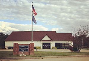
Chandler Community Center
|
||
|
||

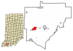
Location of Chandler in Warrick County, Indiana.
|
||
| Country | United States | |
| State | Indiana | |
| County | Warrick | |
| Townships | Boon, Ohio | |
| Area | ||
| • Total | 2.91 sq mi (7.55 km2) | |
| • Land | 2.91 sq mi (7.55 km2) | |
| • Water | 0.00 sq mi (0.00 km2) | |
| Elevation | 387 ft (118 m) | |
| Population
(2020)
|
||
| • Total | 3,693 | |
| • Density | 1,267.33/sq mi (489.29/km2) | |
| Time zone | UTC-6 (CST) | |
| • Summer (DST) | UTC-5 (CDT) | |
| ZIP code |
47610
|
|
| Area code(s) | 812 | |
| FIPS code | 18-12034 | |
| GNIS feature ID | 2396639 | |
| Website | http://www.townofchandler.org/ | |
Chandler is a town in Warrick County, Indiana, United States. It is located just east of Evansville, Indiana. The town is split between Ohio and Boon Township. In 2020, about 3,693 people lived in Chandler. This makes it the second-largest town in Warrick County, after Boonville. Chandler is part of the larger Evansville metropolitan area.
Contents
History of Chandler
Early Days and the Canal
The area that is now Chandler first got a post office in 1847. It was called Lee back then. Around this time, a part of the Central Canal was finished. This canal was supposed to connect nearby Evansville with Worthington.
The canal system was never fully completed. It faced money problems and new competition from railroads. However, some parts of the canal and its old path still exist today. This path is now called Tow Path Road.
How Chandler Got Its Name
In 1874, the town of Lee officially changed its name to Chandler. It was named after O.E. Chandler. He was the foreman for the Lake Erie, Evansville & South Western Railroad. This railroad had built a new track through the town the year before.
The railroad used the old creek bed from the failed canal project. This created a rail line from Evansville through Chandler to Gentryville. Today, this line is no longer used for passenger trains. However, Norfolk Southern still uses a part of the railway for cargo trains. The old Chandler Depot building is still there, but it is now a private home.
Coal Mining in Chandler
In 1875, the first underground coal mine opened in Chandler. It was called Chandler Mine. Warrick County has a lot of coal because it's on the edge of the Illinois Basin. When coal became important for trains and making electricity, many companies came to the area to mine it.
Chandler had six different underground mines operating at various times. No more than three mines were open at the same time. The Erie Canal/Air Line Mine was open for the longest, operating for 40 years until 1937.
Town Growth and Incorporation
By the mid-1940s, most of the mines had closed. This allowed for more building above ground. The construction business grew quickly. In just five years, many new houses were built, and the town's population more than doubled.
In 1953, Chandler officially became an incorporated town. This meant it could have its own local government. Three trustees and a clerk-treasurer were elected to lead the town. Over the next 20 years, town officials and residents worked to improve Chandler.
They created a volunteer fire department and improved streets. They also installed street lights. The town built water wells and a water treatment plant. They also completed a sewer system. They even bought a building for town offices. More recently, the town has continued to grow with new homes, businesses, and industries.
Geography and Climate
Chandler's Location and Size
According to the 2010 census, Chandler covers a total area of about 2.03 square miles (5.26 square kilometers). All of this area is land.
Local Climate
The climate in Chandler has hot and humid summers. Winters are generally cool to cold. Chandler has a humid subtropical climate. This means it gets plenty of rain all year, and it doesn't usually have very cold winters.
Population Information
| Historical population | |||
|---|---|---|---|
| Census | Pop. | %± | |
| 1960 | 1,784 | — | |
| 1970 | 2,032 | 13.9% | |
| 1980 | 3,043 | 49.8% | |
| 1990 | 3,099 | 1.8% | |
| 2000 | 3,094 | −0.2% | |
| 2010 | 2,887 | −6.7% | |
| 2020 | 3,693 | 27.9% | |
| U.S. Decennial Census | |||
Population in 2010
In 2010, there were 2,887 people living in Chandler. There were 1,101 households and 791 families. The town had about 1,422 people per square mile (549 people per square kilometer).
Most of the people in Chandler were White (97.9%). A small number were African American, Native American, or Asian. About 1.3% of the population was Hispanic or Latino.
About 37.1% of households had children under 18 living with them. Many households (52.4%) were married couples. The average household had 2.62 people, and the average family had 3.06 people.
The average age in Chandler was 36 years old. About 27.2% of residents were under 18. About 11.6% were 65 years or older. The town had slightly more females (51.2%) than males (48.8%).
Education
Chandler has a public library. It is a part of the Ohio Township Public Library System.
Transportation
The Warrick Area Transit System (WATS) provides bus service in Chandler. This service connects Chandler to the bus system in Evansville.
See also
 In Spanish: Chandler (Indiana) para niños
 | Janet Taylor Pickett |
 | Synthia Saint James |
 | Howardena Pindell |
 | Faith Ringgold |


