Chattanooga Valley, Georgia facts for kids
Quick facts for kids
Chattanooga Valley, Georgia
|
|
|---|---|

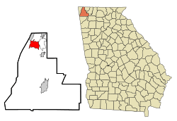
Location in Walker County and the state of Georgia
|
|
| Country | United States |
| State | Georgia |
| County | Walker |
| Area | |
| • Total | 7.42 sq mi (19.22 km2) |
| • Land | 7.42 sq mi (19.22 km2) |
| • Water | 0.00 sq mi (0.00 km2) |
| Elevation | 715 ft (218 m) |
| Population
(2020)
|
|
| • Total | 3,962 |
| • Density | 533.96/sq mi (206.17/km2) |
| Time zone | UTC-5 (Eastern (EST)) |
| • Summer (DST) | UTC-4 (EDT) |
| Area code(s) | 706/762 |
| FIPS code | 13-15585 |
| GNIS feature ID | 2402766 |
Chattanooga Valley is a community in Walker County, Georgia, United States. It is called an unincorporated community. This means it's a recognized area but doesn't have its own local government. It's also a census-designated place (CDP), which means the U.S. Census Bureau counts its population separately.
In 2020, about 3,962 people lived there. Chattanooga Valley is part of the larger Chattanooga, TN–GA Metropolitan Statistical Area. The name "Chattanooga" comes from a Muskogean-language word. It means "rock coming to a point."
Contents
Where is Chattanooga Valley?
Chattanooga Valley is located in the state of Georgia. You can find it at these coordinates: 34.922236 degrees North and -85.335453 degrees West.
The United States Census Bureau says that the entire area of Chattanooga Valley is land. It covers about 7.5 square miles (19.22 square kilometers). There is no water area within the CDP.
How Many People Live Here?
The population of Chattanooga Valley has changed over the years. The U.S. Census Bureau counts how many people live in an area every ten years.
| Historical population | |||
|---|---|---|---|
| Census | Pop. | %± | |
| 1990 | 4,088 | — | |
| 2000 | 4,065 | −0.6% | |
| 2010 | 3,846 | −5.4% | |
| 2020 | 3,962 | 3.0% | |
| U.S. Decennial Census | |||
Chattanooga Valley was first counted as a census-designated place in the 1990 U.S. Census.
Who Lives in Chattanooga Valley?
The table below shows the different groups of people living in Chattanooga Valley. The U.S. Census counts people by their race and ethnicity. Hispanic/Latino is an ethnic group, and people from this group can be of any race.
| Race / Ethnicity (NH = Not Hispanic) | Pop 2000 | Pop 2010 | Pop 2020 | % 2000 | % 2010 | % 2020 |
|---|---|---|---|---|---|---|
| White alone (NH) | 3,978 | 3,678 | 3,563 | 97.86% | 95.63% | 89.93% |
| Black or African American alone (NH) | 21 | 36 | 77 | 0.52% | 0.94% | 1.94% |
| Native American or Alaska Native alone (NH) | 12 | 18 | 6 | 0.30% | 0.47% | 0.15% |
| Asian alone (NH) | 9 | 11 | 7 | 0.22% | 0.29% | 0.18% |
| Pacific Islander alone (NH) | 0 | 1 | 2 | 0.00% | 0.03% | 0.05% |
| Some Other Race alone (NH) | 0 | 0 | 6 | 0.00% | 0.00% | 0.15% |
| Mixed race or Multiracial (NH) | 17 | 39 | 199 | 0.42% | 1.01% | 5.02% |
| Hispanic or Latino (any race) | 28 | 63 | 102 | 0.69% | 1.64% | 2.57% |
| Total | 4,065 | 3,846 | 3,962 | 100.00% | 100.00% | 100.00% |
See also
 In Spanish: Chattanooga Valley para niños
 | Selma Burke |
 | Pauline Powell Burns |
 | Frederick J. Brown |
 | Robert Blackburn |

