
Chelsea, Oklahoma facts for kids
Quick facts for kids
Chelsea, Oklahoma
|
|
|---|---|

Location in Oklahoma
|
|
| Country | United States |
| State | Oklahoma |
| County | Rogers |
| Area | |
| • Total | 1.78 sq mi (4.60 km2) |
| • Land | 1.78 sq mi (4.60 km2) |
| • Water | 0.00 sq mi (0.00 km2) |
| Elevation | 715 ft (218 m) |
| Population
(2020)
|
|
| • Total | 1,991 |
| • Density | 1,120.43/sq mi (432.52/km2) |
| Time zone | UTC-6 (Central) |
| • Summer (DST) | UTC-5 |
| ZIP code |
74016
|
| Area code(s) | 539/918 |
| FIPS code | 40-13700 |
| GNIS feature ID | 2413192 |
Chelsea is a town located in Rogers County, Oklahoma, United States. In 2020, about 1,991 people lived there. The town got its name from a place in London, England. Charles Peach, a railroad worker from London, chose the name.
Chelsea was also home to the Chelsea-Alluwe Oil Field. This oil field produced a lot of oil from around 1910 until the early 1920s. Famous cowboy and entertainer Will Rogers even went to school in Chelsea for a short time.
Contents
History of Chelsea
How Chelsea Started
Chelsea began in 1881 as a stop for the Atlantic and Pacific Railroad. A post office opened in November 1882. The community officially became a town in 1889. This was when it was part of the Cherokee Nation, Indian Territory. The town's layout was planned in 1902. The Bank of Chelsea, which was the first state bank in Indian Territory, opened in 1896.
Early Economy and Oil Discovery
For many years, Chelsea's economy relied on farming, ranching, and oil. Farmers grew oats, corn, wheat, and pecans. A flour mill, built around 1892, was one of the town's first businesses. Before Oklahoma became a state in 1907, Chelsea was important for shipping cattle and hay.
The Chelsea-Alluwe oil field was found southwest of Chelsea in 1889. This happened when the United States Oil and Gas Company started drilling.
The First Oil Well Claim
In 1882, Edward Byrd found oil seeps near Chelsea. His wife was a Cherokee woman. He didn't do much with his discovery until 1887. Then, he teamed up with William B. Linn and other investors. They formed the United States Oil and Gas Company (USOGC).
This company got rights to drill on a large area of land. In 1890, they finished their first oil well. It produced a small amount of oil each day. People at USOGC claimed it was "the first oil well in Oklahoma."
However, this claim turned out not to be true. The company drilled more wells, but they didn't produce much oil. The Cherokee Oil and Gas Company later took over. They and other companies drilled more successful wells. The whole area became known as the Chelsea-Alluwe Oil Field. Oil production slowed down after 1916.
Geography of Chelsea
Chelsea is located about 19 miles (31 km) northeast of Claremore. It is also about 47 miles (76 km) northeast of Tulsa.
The United States Census Bureau says that Chelsea covers about 1.7 square miles (4.4 km2). All of this area is land.
Population Information
| Historical population | |||
|---|---|---|---|
| Census | Pop. | %± | |
| 1900 | 566 | — | |
| 1910 | 1,350 | 138.5% | |
| 1920 | 1,692 | 25.3% | |
| 1930 | 1,527 | −9.8% | |
| 1940 | 1,642 | 7.5% | |
| 1950 | 1,437 | −12.5% | |
| 1960 | 1,541 | 7.2% | |
| 1970 | 1,622 | 5.3% | |
| 1980 | 1,754 | 8.1% | |
| 1990 | 1,620 | −7.6% | |
| 2000 | 2,136 | 31.9% | |
| 2010 | 1,964 | −8.1% | |
| 2020 | 1,991 | 1.4% | |
| U.S. Decennial Census | |||
In 2000, Chelsea had 2,136 people living there. There were 835 households. About 35% of these households had children under 18. The average household had about 2.5 people.
The population was spread out by age. About 30% were under 18 years old. About 17% were 65 years or older. The average age in Chelsea was 33 years old.
Education in Chelsea
Chelsea High School teaches students from kindergarten through 12th grade. The school has had success in sports and academics.
- In 1998, the boys' track team won the state championship.
- In 2007, the Varsity cheerleading squad won the state championship.
- Also in 2007, the softball team won the state championship.
- In 2013, the Chelsea Academic team won the 3A State Championship.
- Chelsea is also known for its FFA (Future Farmers of America) organization.
Historic Places in Chelsea
Several places in Chelsea are listed on the National Register of Historic Places. This means they are important historical sites.
- Chelsea Motel
- Hogue House
- Pryor Creek Bridge
Famous People from Chelsea
- Gar Moore – An actor.
- Ralph Terry – A pitcher who won the World Series MVP award. He played for the Chelsea High School Green Dragons baseball team.
Images for kids
-
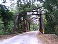
Pryor Creek Bridge
-
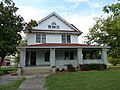
Hogue House


See also
 In Spanish: Chelsea (Oklahoma) para niños
