Cheriton, Virginia facts for kids
Quick facts for kids
Cheriton, Virginia
|
|
|---|---|
| Motto(s):
Small town, big heart
|
|

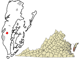
Location in Northampton County and the state of Virginia.
|
|
| Country | United States |
| State | Virginia |
| County | Northampton |
| Named for | Cheriton, Kent |
| Area | |
| • Total | 1.09 sq mi (2.83 km2) |
| • Land | 1.09 sq mi (2.82 km2) |
| • Water | 0.01 sq mi (0.01 km2) |
| Elevation | 20 ft (6 m) |
| Population
(2020)
|
|
| • Total | 486 |
| • Density | 446.7/sq mi (172.5/km2) |
| Time zone | UTC−5 (Eastern (EST)) |
| • Summer (DST) | UTC−4 (EDT) |
| ZIP code |
23316
|
| Area code(s) | 757, 948 |
| FIPS code | 51-15112 |
| GNIS feature ID | 1492747 |
| Website | Official Website: https://townofcheriton.org/ |
Cheriton is a small town located in Northampton County, which is part of the state of Virginia in the United States. In 2020, about 486 people lived there. It is known for being a friendly community.
Contents
History of Cheriton
Cheriton has an interesting past. A very old and important house called Eyre Hall is located here. This house was added to the National Register of Historic Places in 1969. This means it is a special place that is worth protecting. Later, in 2012, it was named a National Historic Landmark. This is an even higher honor, showing its great importance to the history of the United States.
Where is Cheriton Located?
Cheriton is found at specific coordinates: 37.289443 degrees North and 75.968201 degrees West. It is right along U.S. Route 13. This is a major road that connects many places. Another road, State Route 184, also meets U.S. Route 13 in Cheriton.
How Big is Cheriton?
The town of Cheriton covers a total area of about 1.0 square mile (2.7 square kilometers). Almost all of this area is land. Only a tiny part, less than 1%, is water.
Who Lives in Cheriton?
The number of people living in Cheriton has changed over the years.
| Historical population | |||
|---|---|---|---|
| Census | Pop. | %± | |
| 1960 | 761 | — | |
| 1970 | 655 | −13.9% | |
| 1980 | 695 | 6.1% | |
| 1990 | 515 | −25.9% | |
| 2000 | 499 | −3.1% | |
| 2010 | 487 | −2.4% | |
| 2020 | 486 | −0.2% | |
| U.S. Decennial Census | |||
In the year 2000, there were 499 people living in Cheriton. These people lived in 219 different homes. About 134 of these homes were families. The town had about 486 people per square mile.
Age Groups in Cheriton
The people in Cheriton come from all age groups. In 2000, about 21.8% of the people were under 18 years old. About 23.6% of the people were 65 years old or older. The average age in the town was 44 years.
Getting Around Cheriton
Cheriton is connected by several important roads.
Main Roads
- U.S. Route 13
- U.S. Route 13 Business (a local route through Cheriton)
- Virginia State Route 184
Public Transportation
If you need to get around without a car, STAR Transit offers bus services. These buses connect Cheriton to nearby towns like Cape Charles and Onley. They also link to other communities in Northampton and Accomack counties.
Railroads
For many years, the Bay Coast Railroad helped move goods in and out of Cheriton. This was a freight rail service, meaning it carried cargo, not passengers. However, this railroad stopped operating in 2018.
Famous People from Cheriton
Some notable people were born in Cheriton:
- Mignon Holland Anderson: She is a talented author.
- Henry Wise Jr.: He was a Tuskegee Airman and a doctor. Tuskegee Airmen were a group of African-American military pilots who fought during World War II.
Cheriton's Climate
The weather in Cheriton is usually warm and humid in the summer. Winters are generally mild, meaning not too cold. This type of weather is called a humid subtropical climate. On climate maps, it is often shown as "Cfa."
See also
 In Spanish: Cheriton (Virginia) para niños
 | Ernest Everett Just |
 | Mary Jackson |
 | Emmett Chappelle |
 | Marie Maynard Daly |

