Cherokee, Oklahoma facts for kids
Quick facts for kids
Cherokee, Oklahoma
|
|
|---|---|

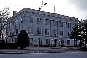
Alfalfa County Courthouse in Cherokee (2007)
|
|

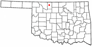
Location within Oklahoma
|
|
| Country | United States |
| State | Oklahoma |
| County | Alfalfa |
| Area | |
| • Total | 2.04 sq mi (5.29 km2) |
| • Land | 2.04 sq mi (5.29 km2) |
| • Water | 0.00 sq mi (0.00 km2) |
| Elevation | 1,178 ft (359 m) |
| Population
(2020)
|
|
| • Total | 1,476 |
| • Density | 722.82/sq mi (279.05/km2) |
| Time zone | UTC-6 (Central (CST)) |
| • Summer (DST) | UTC-5 (CDT) |
| ZIP code |
73728
|
| Area code | 580 |
| FIPS code | 40-13750 |
| GNIS ID | 2409442 |
Cherokee is the biggest city in Alfalfa County, Oklahoma, United States. It's also the county seat, which means it's where the main government offices for the county are located. In 2020, about 1,476 people lived here.
History of Cherokee
How Cherokee Started
After a big land opening in 1893, people wanted to build railroads through the area. This would help transport large amounts of wheat to markets. A company bought 100 acres of land and planned the town of Cherokee. They sold lots on February 9, 1901. Cherokee officially became a town in July 1901.
Two years later, the Kansas City, Mexico and Orient Railroad built a train line through Cherokee. People from a nearby community called Erwin moved to Cherokee to be closer to the railroad. Erwin then disappeared, and Cherokee took its place. The post office was renamed "Cherokee" in March 1903.
Growing with Railroads
By 1905, another railroad, the Denver, Enid and Gulf Railroad, also built a line through Cherokee. This made Cherokee a very important center for farming services, banking, and trade in the region. It served smaller towns nearby. The town grew around its two train stations.
By 1909, Cherokee had three banks, three newspapers, and several mills. There was a factory that made concrete blocks and another that made school desks. Many different churches were also built, including Baptist, Catholic, and Methodist.
Alfalfa County was created in 1907 when Oklahoma became a state. It was named after Governor William H. Murray. Cherokee was officially confirmed as the county seat in January 1909.
Years of Growth and Change
In 1918, a hospital moved to Cherokee from a nearby town. A new high school was finished in 1921. Many businesses provided jobs, like a flour mill, a battery factory, and an ice plant. A new county courthouse was completed in 1924. The 1920s also saw improvements like better streets and a public water supply.
Oil discoveries in the county during the late 1920s and mid-1930s also helped the city's economy. Several oil companies had storage facilities near the railroad. Even during the Great Depression, Cherokee was an important trading center.
Cherokee was better prepared for the hard times of the Depression than many other towns. It had many hotels, like The Hotel Cherokee and the Orient Hotel. Business owners worked hard to make Cherokee a popular place for meetings and conventions. They successfully attracted groups like the 4-H Clubs and the Woman's Christian Temperance Union.
By 1936, Cherokee had many businesses, including eleven gas stations, five car dealerships, and four grain elevators. There were also nine restaurants, five grocery stores, two bakeries, and two banks. Two newspapers, the Alfalfa County News and the Cherokee Messenger, kept people informed.
The Works Progress Administration (WPA) built a National Guard Armory in 1937 and a public library in 1939. The nearby Great Salt Plains area attracted hunters, which also helped the local economy. A dam built on the Salt Fork of the Arkansas River from 1938 to 1941 created the Great Salt Plains Lake. This made the area even better for hunting and tourism.
Cherokee from the 1950s Onward
Cherokee's population was largest in 1950, with 2,635 people. Since then, the population has slowly decreased. By 1970, there were 125 businesses and 2,119 residents. The county took over the hospital in 1976. A new industrial park was also created in that decade. By 1990, the population dropped below 2,000 for the first time since Cherokee became the county seat.
The Santa Fe Railroad continued to operate its main line through Cherokee until the mid-1990s. The east-west line, which became part of the BNSF Railway, stopped operations shortly after.
Today, Cherokee has a city manager form of government. It has three parks and a swimming pool. Cherokee is home to one of the three public school districts in the county. The high school mascot is the Cherokee Chiefs.
Historic Places in Cherokee
Several places in Cherokee are listed on the National Register of Historic Places (NRHP). These include:
- The Cherokee Friends Church, built in 1919.
- The Cherokee IOOF Lodge No. 219, built in 1931.
- The Farmers' Federation Elevator (around 1917).
- The Alfalfa County Courthouse (around 1921).
- The Cherokee National Guard Armory (around 1936).
- The Hotel Cherokee (around 1929), which is now the county history center.
Geography and Climate
Where is Cherokee?
Cherokee is located in northern Oklahoma. It sits along U.S. Highway 64 and State Highway 8. The city covers about 1.473 square miles of land.
A few miles southeast of Cherokee is the Salt Plains National Wildlife Refuge. This area is famous for its unique, hour-glass shaped selenite crystals.
On July 11, 1909, a rare weather event called a heat burst happened south of Cherokee. The temperature reportedly rose very quickly to 136°F (58°C), drying out crops in the area.
Cherokee's Climate
Cherokee has a humid subtropical climate (like a warm, wet climate) but also gets some influence from a cool semi-arid climate (drier and cooler).
| Climate data for Cherokee, Oklahoma | |||||||||||||
|---|---|---|---|---|---|---|---|---|---|---|---|---|---|
| Month | Jan | Feb | Mar | Apr | May | Jun | Jul | Aug | Sep | Oct | Nov | Dec | Year |
| Record high °F (°C) | 86 (30) |
91 (33) |
96 (36) |
100 (38) |
105 (41) |
115 (46) |
117 (47) |
117 (47) |
111 (44) |
101 (38) |
90 (32) |
85 (29) |
117 (47) |
| Mean daily maximum °F (°C) | 47.1 (8.4) |
52.7 (11.5) |
62.8 (17.1) |
72.6 (22.6) |
81.3 (27.4) |
91.1 (32.8) |
96.7 (35.9) |
95.8 (35.4) |
86.9 (30.5) |
75.8 (24.3) |
60.3 (15.7) |
49.4 (9.7) |
72.7 (22.6) |
| Mean daily minimum °F (°C) | 22.7 (−5.2) |
26.9 (−2.8) |
35.2 (1.8) |
45.0 (7.2) |
55.4 (13.0) |
65.3 (18.5) |
70.2 (21.2) |
69.3 (20.7) |
60.5 (15.8) |
48.2 (9.0) |
34.8 (1.6) |
25.7 (−3.5) |
46.6 (8.1) |
| Record low °F (°C) | −15 (−26) |
−15 (−26) |
−1 (−18) |
13 (−11) |
30 (−1) |
36 (2) |
50 (10) |
45 (7) |
30 (−1) |
12 (−11) |
6 (−14) |
−12 (−24) |
−15 (−26) |
| Average precipitation inches (mm) | 0.90 (23) |
1.11 (28) |
2.15 (55) |
2.74 (70) |
4.08 (104) |
4.08 (104) |
2.48 (63) |
2.95 (75) |
2.56 (65) |
1.29 (33) |
1.49 (38) |
1.12 (28) |
26.95 (686) |
| Average snowfall inches (cm) | 2.4 (6.1) |
3.2 (8.1) |
1.7 (4.3) |
0.1 (0.25) |
0.0 (0.0) |
0.0 (0.0) |
0.0 (0.0) |
0.0 (0.0) |
0.0 (0.0) |
0.0 (0.0) |
0.8 (2.0) |
2.7 (6.9) |
10.9 (27.65) |
| Average precipitation days (≥ 0.01 inch) | 3 | 4 | 5 | 6 | 7 | 7 | 5 | 6 | 5 | 5 | 3 | 3 | 58 |
| Source: Western Regional Climate Center | |||||||||||||
It's important to know that many claims of extremely high temperatures are hard to prove. This is because the equipment used at the time might not have been accurate. The highest temperature ever officially recorded for Oklahoma is 120°F (48.8°C). The world's highest proven temperature is 134°F (56.7°C), recorded in Death Valley, USA, on July 10, 1913.
Population of Cherokee
| Historical population | |||
|---|---|---|---|
| Census | Pop. | %± | |
| 1910 | 2,016 | — | |
| 1920 | 2,017 | 0.0% | |
| 1930 | 2,236 | 10.9% | |
| 1940 | 2,553 | 14.2% | |
| 1950 | 2,635 | 3.2% | |
| 1960 | 2,410 | −8.5% | |
| 1970 | 2,119 | −12.1% | |
| 1980 | 2,105 | −0.7% | |
| 1990 | 1,787 | −15.1% | |
| 2000 | 1,630 | −8.8% | |
| 2010 | 1,498 | −8.1% | |
| 2020 | 1,476 | −1.5% | |
| U.S. Decennial Census | |||
Cherokee's Population in 2000
In the year 2000, about 1,630 people lived in Cherokee. There were 709 households, and 450 of them were families. Most people living in Cherokee were White (95.52%). About 1.72% were Native American.
In terms of age, 24.6% of the population was under 18 years old. About 23.1% were 65 years or older. The average age in the city was 42 years.
Cherokee's Population in 2010
By 2010, the population of Cherokee was 1,498 people. There were 647 households. Most residents (93.6%) were White. About 2.8% were American Indian or Alaska Native. The population was almost evenly split between males (49.9%) and females (50.1%). The average age was 44.3 years.
Economy
Cherokee is mainly a farming community. Historically, oil field activities also played a big part in the city's success and growth.
See also
 In Spanish: Cherokee (Oklahoma) para niños
 | Chris Smalls |
 | Fred Hampton |
 | Ralph Abernathy |


