Cherokee Village, Arkansas facts for kids
Quick facts for kids
Cherokee Village
|
|||
|---|---|---|---|
|
|||

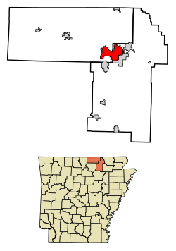
Location of Cherokee Village in Fulton County and Sharp County, Arkansas.
|
|||
| Country | United States | ||
| State | Arkansas | ||
| Counties | Sharp, Fulton | ||
| Area | |||
| • Total | 21.31 sq mi (55.19 km2) | ||
| • Land | 20.43 sq mi (52.91 km2) | ||
| • Water | 0.88 sq mi (2.28 km2) | ||
| Elevation | 692 ft (211 m) | ||
| Population
(2020)
|
|||
| • Total | 4,780 | ||
| • Density | 234.00/sq mi (90.35/km2) | ||
| Time zone | UTC-6 (Central (CST)) | ||
| • Summer (DST) | UTC-5 (CDT) | ||
| ZIP codes |
72525, 72529
|
||
| Area code(s) | 870 | ||
| FIPS code | 05-13450 | ||
| GNIS feature ID | 2404038 | ||
Cherokee Village is a city located in Fulton and Sharp counties in the state of Arkansas. In 2020, about 4,780 people lived here. It is known for being a planned community with lots of outdoor activities.
Contents
History of Cherokee Village
How Cherokee Village Started
In 1948, a man named John Cooper, Sr. bought 400 acres of land. He wanted to create a summer getaway for his family. He soon realized that other families would enjoy a similar place. So, he bought more land, reaching a total of 2,400 acres.
He then started planning out areas for homes and building lakes. In 1954, he created the Cherokee Village Development Company. This was the first planned recreation community in Arkansas. It was also one of the first of its kind in the entire country.
Growth and Development
Cherokee Village officially opened in June 1955. At that time, it had one lake and a small airstrip. Over the years, it grew into a larger community.
In 1976, a special group was formed called the Cherokee Village Suburban Improvement District (CVSID). This group helped provide important services. These services included fire protection, street maintenance, police security, and caring for parks.
Becoming a City
Cherokee Village became a city in 1997. First, the part of the area in Fulton County became a city. Then, in 1998, the part in Sharp County joined. This made the entire area one city.
Today, Cherokee Village is the largest city in its area. It covers over 13,000 acres. It also has more than 300 miles of paved roads.
Modern Cherokee Village Features
The city has many great features for its residents and visitors. It has 7 lakes and 2 golf courses. There is also an outdoor pool and several marinas. The city has 3 fire stations, many churches, and various clubs.
Cherokee Village is run by a mayor and a city council. This type of government helps manage the city's services. The city handles police, fire, streets, and planning. The CVSID still takes care of the parks, golf courses, and lakes.
Geography of Cherokee Village
Location and Size
Cherokee Village is located at 36°17′36″N 91°34′20″W / 36.29333°N 91.57222°W. The city covers a total area of about 20.8 square miles (53.9 km2). Most of this area, about 19.9 square miles (51.5 km2), is land. The rest, about 0.9 square miles (2.3 km2), is water.
Lakes and Recreation
The city limits include seven beautiful lakes and two marinas. The biggest lake is Lake Thunderbird. It has over seven miles of shoreline. These lakes make the area very popular. Many people come here for vacations. Some buy vacation homes, while others rent properties for a few weeks.
Population and People
How Many People Live Here?
The population of Cherokee Village has grown steadily.
| Historical population | |||
|---|---|---|---|
| Census | Pop. | %± | |
| 2000 | 4,648 | — | |
| 2010 | 4,671 | 0.5% | |
| 2020 | 4,780 | 2.3% | |
| U.S. Decennial Census 2014 Estimate |
|||
Who Lives in Cherokee Village?
The 2020 United States census counted 4,780 people living in Cherokee Village. There were 2,370 households and 1,335 families.
| Race | Number | Percentage |
|---|---|---|
| White (non-Hispanic) | 4,391 | 91.86% |
| Black or African American (non-Hispanic) | 21 | 0.44% |
| Native American | 27 | 0.56% |
| Asian | 34 | 0.71% |
| Pacific Islander | 2 | 0.04% |
| Other/Mixed | 226 | 4.73% |
| Hispanic or Latino | 79 | 1.65% |
Famous People from Cherokee Village
- Tommy Bolt, a famous golfer who is in the World Golf Hall of Fame.
- Garrard Conley, an American author.
See also
 In Spanish: Cherokee Village para niños
 | William L. Dawson |
 | W. E. B. Du Bois |
 | Harry Belafonte |


