Cherryville, South Australia facts for kids
Quick facts for kids CherryvilleSouth Australia |
|
|---|---|

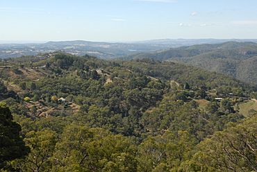
The town of Cherryville seen from Marble Hill
|
|
| Established | 1840 |
| Postcode(s) | 5134 |
| Elevation | 493 m (1,617 ft) |
| Location | 15 km (9 mi) from Adelaide |
| LGA(s) | Adelaide Hills Council |
| State electorate(s) | Heysen |
| Federal Division(s) | Mayo |
Cherryville is a small, pretty town located in the Adelaide Hills region of South Australia. It is known for its beautiful scenery and quiet country feel. The town is about 15 kilometers (9 miles) east of Adelaide, the capital city of South Australia.
What's in a Name?
Cherryville got its name around 1840. It was named after the native cherry trees (called native cherry) that grew all over the area. These trees are special because their "fruit" grows on the outside of the seed.
However, some people think the town was named later, around 1892. This was when many regular cherry trees were planted for farming. Before this, the land was mostly used for raising animals or growing small vegetable gardens.
A Look at History
Cherryville has a simple but interesting history. For many years, it was a quiet farming community.
The Post Office
The Cherryville Post Office first opened its doors on January 2, 1899. This was an important place for people to send and receive letters and packages. It helped connect the town with the rest of Australia. The Post Office served the community for many years before closing in 1974.
The 2013 Bushfire
In May 2013, Cherryville became well-known across Australia for a serious event. A large 2013 Cherryville bushfire broke out in the area. This fire burned about 670 hectares (1,656 acres) of bushland and farms around the town.
This fire was unusual because it happened outside the normal "fire-ban season." This is the time of year when the risk of bushfires is usually highest. The Cherryville fire led to discussions about how to better prepare for fires at any time of the year.
 | Bessie Coleman |
 | Spann Watson |
 | Jill E. Brown |
 | Sherman W. White |


