Chetopa, Kansas facts for kids
Quick facts for kids
Chetopa, Kansas
|
|
|---|---|

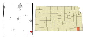
Location within Labette County and Kansas
|
|

|
|
| Country | United States |
| State | Kansas |
| County | Labette |
| Incorporated | 1857 |
| Named for | Chief Chetopah |
| Area | |
| • Total | 1.44 sq mi (3.74 km2) |
| • Land | 1.36 sq mi (3.53 km2) |
| • Water | 0.08 sq mi (0.20 km2) |
| Elevation | 824 ft (251 m) |
| Population
(2020)
|
|
| • Total | 929 |
| • Density | 645.1/sq mi (248.4/km2) |
| Time zone | UTC-6 (CST) |
| • Summer (DST) | UTC-5 (CDT) |
| ZIP code |
67336
|
| Area code | 620 |
| FIPS code | 20-12950 |
| GNIS ID | 469285 |
Chetopa is a small city in Labette County, Kansas, United States. In 2020, about 929 people lived there. The city gets its name from Chief Chetopah, an important Osage Indian chief. Over time, the "h" was dropped from the name.
Contents
History of Chetopa
Chetopa started as an Osage village. It was named after Chief Chetopah. His name meant "four lodges" in the Osage language. Chief Chetopah was known for promoting peace. He was a main leader of the Little Osage tribe. He was also a chief counselor for the whole Osage Nation.
In 1847, a trading post was set up here. People exchanged goods with the Osage Nation at this post. Larkin McGhee started this trading post. When he arrived, a few other families were already living in Chetopa. Many Osage people also lived there.
Chetopa was the site of a small conflict on September 18, 1861. The 6th Kansas Cavalry, led by James G. Blunt, was involved. They faced pro-slavery raiders. These raiders were led by John Allen Mathews. His wife was Osage, and he was connected to the Osage culture.
The first post office in Chetopa opened in April 1867. In 1880, the Postmaster, J.M. Cavaness, asked to remove the "h" from "Chetopah." This is how the city became known as Chetopa.
Chetopa was the end point for the Nevada and Minden Railway. This railway was finished in 1886. The town gave land for the railway tracks and a depot. This helped attract the railway line. The line ran from Nevada, Missouri through Pittsburg, Kansas. Today, much of this old railway track is no longer used.
Geography and Climate
Chetopa is located at 37°2′15″N 95°5′31″W / 37.03750°N 95.09194°W. The city covers about 1.42 square miles (3.7 square kilometers). Most of this area is land. A small part, about 0.08 square miles (0.20 square kilometers), is water.
Chetopa's Weather
The weather in Chetopa has hot and humid summers. The winters are usually mild to cool. This type of weather is called a humid subtropical climate. On climate maps, it's shown as "Cfa."
Population Information
| Historical population | |||
|---|---|---|---|
| Census | Pop. | %± | |
| 1870 | 960 | — | |
| 1880 | 1,305 | 35.9% | |
| 1890 | 2,265 | 73.6% | |
| 1900 | 2,019 | −10.9% | |
| 1910 | 1,548 | −23.3% | |
| 1920 | 1,519 | −1.9% | |
| 1930 | 1,344 | −11.5% | |
| 1940 | 1,606 | 19.5% | |
| 1950 | 1,671 | 4.0% | |
| 1960 | 1,538 | −8.0% | |
| 1970 | 1,596 | 3.8% | |
| 1980 | 1,751 | 9.7% | |
| 1990 | 1,357 | −22.5% | |
| 2000 | 1,281 | −5.6% | |
| 2010 | 1,125 | −12.2% | |
| 2020 | 929 | −17.4% | |
| U.S. Decennial Census | |||
The 2020 United States census counted 929 people living in Chetopa. There were 430 households. About 24% of households had children under 18. The average age in the city was about 49.9 years.
Education in Chetopa
Students in Chetopa attend schools in the Chetopa–St. Paul USD 505 public school district. There are three main schools:
- Chetopa Elementary School
- Chetopa Junior High School
- Chetopa High School
Chetopa also has a public library. The Chetopa Public Library is located at 312 Maple Street. There is also a Historical Preservation Society of Labette County. Their goal is to protect historical places in Labette County for the future.
See also
 In Spanish: Chetopa para niños

