Chicago, Milwaukee, St. Paul and Pacific Railroad Company Historic District facts for kids
Quick facts for kids |
|
|
Chicago, Milwaukee, St. Paul and Pacific Railroad Company Historic District
|
|
 |
|
| Nearest city | Avery, Idaho |
|---|---|
| Area | 48 acres (Montana) 655 acres (Idaho) linear distance: 14.5 mi |
| Built | 1909 |
| Architect | Chicago, Milwaukee, St. Paul and Pacific Railroad |
| NRHP reference No. | 00001269 |
| Added to NRHP | October 26, 2000 |
The Chicago, Milwaukee, St. Paul and Pacific Railroad Company Historic District is a special part of an old train line. It's located in the Bitterroot Mountains in Montana and Idaho. This district covers about 14.5 miles of the path where the Chicago, Milwaukee, St. Paul and Pacific Railroad (also called The Milwaukee Road) once ran. This railroad used to connect Chicago, Illinois all the way to Tacoma, Washington.
Contents
Building a Railroad Across America
The Milwaukee Road was the last major railroad to build tracks all the way across the United States. The company wanted to compete with other big railroads like the Northern Pacific Railroad. So, in 1906, they started building a new line called the "Pacific Extension." This new line would stretch from the Midwest to the Pacific Coast.
Engineers looked for the best path for the tracks. They chose St. Paul Pass in the Bitterroot Mountains. This spot was good because there were lots of valuable pine trees nearby. Also, no other railroad was using that area. From the pass, the tracks followed the St. Joe River to Avery, Idaho.
Tunnels and Bridges
Building this part of the railroad was very difficult and expensive. The area was remote, meaning it was far from towns and supplies. The mountains were also very rugged. Workers had to build 14 tunnels and 26 bridges. The tunnel at St. Paul Pass was especially long, stretching for about 8,771 feet.
Electric Trains
Starting in 1914, The Milwaukee Road began to use electricity for its trains in the mountains. They built special power stations at East Portal and Avery. Overhead wires, called catenary lines, were placed above the tracks. These wires supplied power to the electric trains. However, in 1974, the railroad stopped using electric trains.
The End of the Line and a New Beginning
In 1980, The Milwaukee Road company faced financial trouble and stopped using its tracks west of Miles City, Montana. The old railroad path in Idaho was sold off. In 1985, the United States government bought the section from Avery to East Portal.
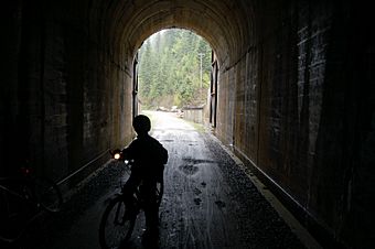
Today, part of the old railroad path has a new purpose. From Avery to Loop Creek, the Forest Service built a road for people to use. The section from Loop Creek to East Portal was turned into a popular bike trail. It is now known as the Route of the Hiawatha Trail.
Why This Place is Important
The old railroad path still looks much like it did when trains ran on it. Many of the original bridges and tunnels are still standing. In some places, you can even see the poles that held the overhead electric wires. There are also signs that were used for snowplows, called flanger signs.
This historic district can also help archaeologists learn more about how the railroad was built. They can study the tools and methods used by the construction crews long ago. Because of its history and how well it has been preserved, this 14.5-mile section of The Milwaukee Road's Pacific Extension was added to the National Register of Historic Places.
 | Delilah Pierce |
 | Gordon Parks |
 | Augusta Savage |
 | Charles Ethan Porter |


