Chico River (Lower Chubut) facts for kids
Quick facts for kids Chico River (Lower Chubut) |
|
|---|---|

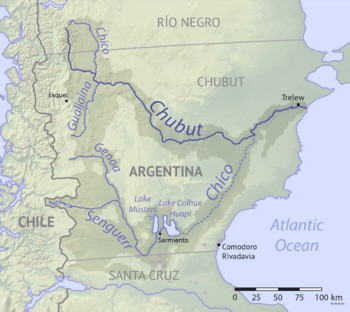
Map of the Chubut drainage basin. The Chico River is shown by the dotted line (lower right).
|
|
| Country | Argentina |
The Chico River is a waterway located in the Chubut Province of Argentina. It stretches for about 300 kilometers (186 miles). This river flows mainly towards the northeast, starting near Lake Colhue Huapi. The Chico River is a branch of the larger Chubut River, joining it at the Florentino Ameghino Dam.
Contents
The Chico River: A Changing Waterway
How the River Used to Flow
For many years, before 1939, the Chico River received water from the Senguerr River. This water flowed into the Chico through an opening on the eastern side of Lake Colhue Huapi. This natural connection helped keep the Chico River flowing.
Why the River is Often Dry Now
Over time, people started using a lot of water from the Senguerr River for irrigation. Irrigation means moving water to help crops grow. This heavy use of water caused the level of Lake Colhue Huapi to drop. Because the lake level went down, the Chico River began to dry up.
Today, the wide valley where the Chico River flows is mostly dry. You will only see water in the Chico River during special times. This happens when there is a lot of snowmelt in the Andes mountains. The Andes are where the Senguerr River begins. When a lot of snow melts, it can provide enough water to temporarily fill parts of the Chico River again.
See also
- In Spanish: Río Chico (Chubut) para niños
- Rivers of Argentina
 | James Van Der Zee |
 | Alma Thomas |
 | Ellis Wilson |
 | Margaret Taylor-Burroughs |

