Chubut River facts for kids
Quick facts for kids Chubut River |
|
|---|---|

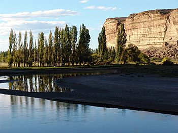
A valley at Chubut River
|
|

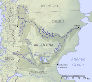
Map of the Chubut drainage basin
|
|
|
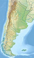
Location of mouth
|
|
| Country | Argentina |
| Province | Chubut Province |
| Physical characteristics | |
| River mouth | 43°20′32″S 65°03′18″W / 43.34233217025459°S 65.05502613544668°W |
The Chubut River is a river in southern Argentina. It flows through the Patagonia region. Its name comes from the Tehuelche word chupat, which means "transparent". The Chubut Province is named after this river.
Welsh settlers, who came to the area, called the river Afon Camwy. This means "twisting river" in Welsh. The Chubut River is usually shallow. Its water flow can change a lot, from 4 cubic metres per second (140 cu ft/s) during dry times to 400 cubic metres per second (14,000 cu ft/s) during floods. On average, it flows at about 60 cubic metres per second (2,100 cu ft/s).
The river's floods made the land next to it very fertile. This was important for farming. The river is very helpful for the province's farms and its economy. People tried to build dams near the towns of Rawson and Gaiman. The Chubut River is special because it is often higher than the dry land around it.
Farming wheat was a main activity for the early settlers. They also grew barley. These crops became important for trading. Controlling the water for irrigation was key for new settlers. They received land from the Argentine government in the lower valley. After a bad harvest in 1881, a new plan for irrigation ditches was made in 1882. This plan helped make sure crops got enough water. It also helped manage the river's changing flow. This system was vital for the whole Chubut valley to survive.
A young Welshman named E. J. Williams managed the building of the canal and irrigation system. He carefully planned a detailed system of ditches and channels. Landowners dug these channels themselves using simple tools. Today, the river is also a popular place for trout fishing.
Where Does the River Flow?
The Chubut River flows east for about 800 kilometres (500 mi). It starts in the Andes mountains and ends in the Atlantic Ocean. The river empties into Engaño Bay near Rawson.
The main part of the Chubut River begins in Carreras, in Río Negro Province. Its basin covers a large area of the western Andean foothills. This area is between Bariloche and Esquel. The river also gets water from the Chico River. Many smaller branches join together before the town of Piedra Parada. Here, the land becomes the flat plains of Argentinian Patagonia. The river then flows east and passes Paso del Sapo. After that, it turns southeast through a less populated part of central Chubut. It meets Highway 25 and then turns east again.
Power from the River
A concrete dam blocks the river about 120 kilometres (75 mi) west of Trelew. This dam is 255-metre (837 ft) long. It is named after the paleontologist Florentino Ameghino. An engineer named Antonio Domingo Pronsato designed the dam in 1943. Building started on April 19, 1963.
The artificial lake created by the dam covers 70 square kilometres (27 sq mi). The power plant uses a 56-metre (184 ft) high waterfall. It has a water flow of 150 cubic metres per second (5,300 cu ft/s) and three turbines. This plant provides energy to several towns. These include Pico Truncado, Caleta Olivia, Comodoro Rivadavia, and the lower Chubut Valley.
A Look Back in Time
In the 1800s, Welsh settlers came to Chubut. They started a colony called Y Wladfa (or Colonia Gales in Spanish) in the Chubut river valley. Even today, you can find the Welsh language and Welsh tea houses in many towns. Many of these towns have Welsh names, like Dolavon and Trelew.
There are old records of floods in the valley almost every year between 1865 and 1884. There were also floods in 1899, 1901, 1902, 1904, 1923, 1932, 1939, 1944, 1945, 1946, 1949, 1950, 1951, and 1958. The floods between 1884 and 1901 caused a lot of damage. They especially affected the town of Gaiman and also Rawson. Because of this, Trelew became more important as it was in a safer spot.
In 1893, flood defenses were built to stop the floods. Since it opened in 1963, the Florentino Ameghino Dam has helped control the river's flow. Even after the dam, there were still floods. Many of these were caused by local rains. These happened in 1964, 1968, 1976, 1992, 1993, 1998, 1999, 2002, 2004, 2006, 2008, 2010, and 2017.
See also
 In Spanish: Río Chubut para niños
 | Madam C. J. Walker |
 | Janet Emerson Bashen |
 | Annie Turnbo Malone |
 | Maggie L. Walker |


