
Chimney Rock, North Carolina facts for kids
Quick facts for kids
Chimney Rock, North Carolina
|
|
|---|---|
|
Village
|
|

Village of Chimney Rock (2006)
|
|

Chimney Rock, North Carolina
Location in North Carolina

Chimney Rock, North Carolina
Location in the United States
|
|
| Country | United States |
| State | North Carolina |
| County | Rutherford |
| Named for | Chimney Rock |
| Area | |
| • Total | 3.36 sq mi (8.70 km2) |
| • Land | 3.36 sq mi (8.69 km2) |
| • Water | 0.00 sq mi (0.01 km2) |
| Elevation | 2,579 ft (786 m) |
| Population
(2020)
|
|
| • Total | 140 |
| • Density | 41.7/sq mi (16.1/km2) |
| Time zone | UTC-5 (Eastern (EST)) |
| • Summer (DST) | UTC-4 (EDT) |
| ZIP code |
28720
|
| Area code | 828 |
| FIPS code | 37-12460 |
| GNIS ID | 2407430 |
Chimney Rock is a small village in Rutherford County, North Carolina, United States. In 2020, about 140 people lived there. The village gets its name from a huge rock formation called Chimney Rock. This rock is located on a mountain peak above the village, inside Chimney Rock State Park.
Contents
History of Chimney Rock
A U.S. post office has been in Chimney Rock since at least 1843. This means people have lived and worked in the area for a long time.
In September 2024, a big flood caused a lot of damage to Chimney Rock. Hurricane Helene brought heavy rains, and the Broad River overflowed into the village. The nearby town of Lake Lure was also badly hit by the flooding.
Geography of Chimney Rock
Chimney Rock village covers about 2.8 square miles (7.2 square kilometers) of land. It shares a border with the town of Lake Lure.
The village is located within a special area called Hickory Nut Gorge. This gorge is a narrow valley that was likely carved out by the Broad River over many years. The river probably followed a path where the rocks were weaker or had cracks.
Geology: The Rocks of Chimney Rock
The mountains and valleys around Chimney Rock are mostly made of a type of rock called Henderson Gneiss. Gneiss (pronounced "nice") is a metamorphic rock. This means it's a rock that has changed over time due to heat and pressure deep inside the Earth.
Scientists have studied the age of the Henderson Gneiss. They found it formed around 535 to 592 million years ago. This was a time when a small piece of Earth's crust, called the Tugaloo terrane, crashed into North America. This collision caused huge amounts of molten rock to push into existing rocks. Over millions of years, these rocks were squeezed and heated, turning them into the Henderson Gneiss we see today.
The rocks in the Chimney Rock area have also been affected by many periods of folding and faulting. This means the rock layers were bent and broken by the powerful forces within the Earth.
Why Landslides Happen
Over time, the Henderson Gneiss has developed many cracks, called joints. These cracks formed as the rock was lifted up and worn away by erosion. Because of these cracks and the steep walls of Hickory Nut Gorge, landslides can happen.
Landslides are when rock and soil slide down a slope. The area has a humid climate, which means lots of rain. This rain can make the ground heavy and unstable. Throughout history, there have been many landslides in Hickory Nut Gorge, including in 1916, 1994, 1996, 2008, 2012, 2013, and 2018. You can even see piles of fallen rocks at the bottom of the gorge, showing that rockfalls have been happening for a very long time.
Population of Chimney Rock
| Historical population | |||
|---|---|---|---|
| Census | Pop. | %± | |
| 2000 | 175 | — | |
| 2010 | 113 | −35.4% | |
| 2020 | 140 | 23.9% | |
| U.S. Decennial Census | |||
People Living in Chimney Rock (2020)
In 2020, there were 140 people living in Chimney Rock. These people made up 81 households, and 48 of those were families.
| Race | Number | Percentage |
|---|---|---|
| White (non-Hispanic) | 126 | 90.0% |
| Pacific Islander | 1 | 0.71% |
| Other/Mixed | 9 | 6.43% |
| Hispanic or Latino | 4 | 2.86% |
Gallery
-
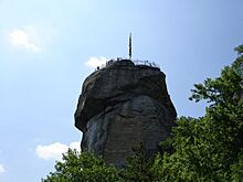
Chimney Rock, a 315-foot (96 m) tall rock in Chimney Rock State Park near the village (2006).
-
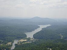
View from the top of Chimney Rock (2011).
.jpg)

See also
In Spanish: Chimney Rock para niños
