Chinautla facts for kids
Chinautla (pronounced chee-nowt-lah) is a city and a special area called a municipality in the Guatemala Department of Guatemala. It's a busy place with a population of over 100,000 people, making it one of the largest cities in the country.
Quick facts for kids
Chinautla
|
|
|---|---|
|
Municipality
|
|

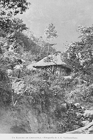
Native residence in Chinautla in 1897
Photograph by Alberto G. Valdeavellano |
|
| Country | |
| Department | Guatemala |
| Area | |
| • Municipality | 21.7 sq mi (56.3 km2) |
| Elevation | 4,042 ft (1,232 m) |
| Population
(2018 census)
|
|
| • Municipality | 114,752 |
| • Density | 5,279/sq mi (2,038.2/km2) |
| • Urban | 104,972 |
| Climate | Aw |
Contents
What is Chinautla?
Chinautla is a municipality, which is like a local government area. It's part of the Guatemala Department, one of the main regions in the country. The city itself is quite large, with many people living and working there.
Villages in Chinautla
The municipality of Chinautla includes the main city and several smaller villages. These villages help make up the larger community. Here are the eleven villages:
- Los Jocotales
- San Martín
- San José Buena Vista
- El Durazno
- Tres Sabanas
- Las Lomas
- Cumbre de Guayabo
- San Antonio las Flores
- San Rafael las Flores
- La Laguneta
- El Chan
- Concepción Sacojito
Chinautla's Weather
Chinautla has a tropical climate. This means it's generally warm all year round. It experiences a "tropical savanna climate," which usually has a wet season and a dry season.
| Climate data for Chinautla | |||||||||||||
|---|---|---|---|---|---|---|---|---|---|---|---|---|---|
| Month | Jan | Feb | Mar | Apr | May | Jun | Jul | Aug | Sep | Oct | Nov | Dec | Year |
| Mean daily maximum °C (°F) | 25.8 (78.4) |
26.8 (80.2) |
28.3 (82.9) |
28.7 (83.7) |
28.4 (83.1) |
27.0 (80.6) |
26.8 (80.2) |
27.1 (80.8) |
26.4 (79.5) |
26.0 (78.8) |
25.8 (78.4) |
25.5 (77.9) |
26.9 (80.4) |
| Daily mean °C (°F) | 19.6 (67.3) |
20.3 (68.5) |
21.6 (70.9) |
22.5 (72.5) |
22.7 (72.9) |
22.2 (72.0) |
21.9 (71.4) |
22.0 (71.6) |
21.6 (70.9) |
21.1 (70.0) |
20.4 (68.7) |
19.6 (67.3) |
21.3 (70.3) |
| Mean daily minimum °C (°F) | 13.5 (56.3) |
13.9 (57.0) |
15.0 (59.0) |
16.3 (61.3) |
17.0 (62.6) |
17.4 (63.3) |
17.1 (62.8) |
16.9 (62.4) |
16.8 (62.2) |
16.2 (61.2) |
15.0 (59.0) |
13.7 (56.7) |
15.7 (60.3) |
| Average precipitation mm (inches) | 1 (0.0) |
2 (0.1) |
5 (0.2) |
25 (1.0) |
103 (4.1) |
207 (8.1) |
187 (7.4) |
132 (5.2) |
211 (8.3) |
96 (3.8) |
16 (0.6) |
2 (0.1) |
987 (38.9) |
| Source: Climate-Data.org | |||||||||||||
Where is Chinautla Located?
Chinautla is right in the middle of the Guatemala Department. It shares its borders only with other municipalities from the same department. This means it's surrounded by its neighbors within the same region.
 |
Chuarrancho |  |
||
| Mixco, San Pedro Sacatepéquez and San Raymundo | San Pedro Ayampuc | |||
| Guatemala City |
See also
 In Spanish: Chinautla para niños
 | Aaron Henry |
 | T. R. M. Howard |
 | Jesse Jackson |


