
Chuckanut Bay facts for kids

Chuckanut Bay is a beautiful, crescent-shaped bay in southwestern Whatcom County, Washington. It is about 3 miles (4.8 km) long and sits directly south of Bellingham, Washington, United States. This bay was formed when the Chuckanut Mountains were created. It is located on the eastern shore of the Salish Sea, at the southeast end of Bellingham Bay.
The bay was first named Puerto del Socorro by Lieut. Juan Francisco de Eliza in 1791. Later, Capt. Henry Roeder chose the name 'Chuckanut' on December 1, 1852. The name 'Chuckanut' comes from a native word that means "Long beach far from a narrow entrance."
Important natural spots in the area include Pleasant Bay to the south and Mud Bay to the north. You can also find Chuckanut Island (also called Dot Island) and Chuckanut Rocks to the west. Other cool places are Teddy Bear Cove, Governors Point, and Clark Point. The main creeks that flow into the bay are Chuckanut Creek and Fragrance Lake Outlet. The bay is also known for its interesting tafoni formations, which are special rock shapes.
Contents
Life in Chuckanut Bay: Communities and Connections
Chuckanut Bay is home to several communities. These areas offer a mix of natural beauty and local history.
Chuckanut Village and Bay Community
Chuckanut Village is the southernmost neighborhood of Bellingham, located near Mud Bay. Further south is the Chuckanut Bay Community. In the 1940s, about 60 people lived there. This community was once a busy ferry landing from 1935 to 1941. Ferries traveled to the San Juan Islands and Sydney, British Columbia. After the ferry service stopped, the landing became the Chuckanut Bay Yacht Club. When the yacht club closed in 1946, its building was moved to LaConner, Washington, and is now a restaurant by the water.
Chuckanut Bay Community Association
Today, the Chuckanut Bay Community Association (CBCA) has over 400 member households. This group is a non-profit organization. It works to build a strong community spirit among people living in the Chuckanut Bay and Chuckanut Mountain areas. The CBCA started in 1992 to help volunteer firefighters in their district. It continues to serve the Chuckanut community today. These communities are connected to Bellingham and Burlington, Washington by State Route 11, also known as Chuckanut Drive.
Chuckanut Beaches Association
The Chuckanut Beaches Association (CBA) is another community group. Its members share access to five different beaches. The CBA was first created in 1954 as Chuckanut Beaches Inc. It was later re-formed in 1994 as the Chuckanut Beaches Association. The five Chuckanut beaches were given to Chuckanut Beaches, Inc. in 1954 by the estate of Charles F. Larrabee. He was the person who donated the land for Larrabee State Park. The deed for the beaches says they are for "park, boat haven, beach and playground purposes."
Chuckanut Bay's Past: A Look Back
Chuckanut Bay has a rich history with many different activities taking place over the years.
Early Industries and Uses
- Stone Quarry: A stone quarry in Chuckanut opened in 1880 and operated until 1908.
- Salmon Cannery: A salmon cannery started in 1900. It later became the Astoria-Puget Sound Cannery. After fish traps were made illegal in 1934, the cannery moved to Alaska. Its old buildings were used as warehouses until 1948.
- Logging: Chuckanut Mountain was logged in the 1890s. The bay was used to float logs and load them onto ships.
- Shipbuilding: Large sailing ships, with three or four masts, were built in the bay in the early 1900s.
- Brick and Tile Plant: A plant that made bricks and tiles opened in 1915 and ran for several years.
- Prohibition Era: During the time of Prohibition, when alcohol was illegal, the bay was used by people who made and transported alcohol secretly.
- Coal Mining: Coal was mined and stone was quarried on the west side of Governors Point in 1921.
- Winter Mooring: In 1902, Pleasant Bay was used as a safe place for sailing ships to stay during the winter.
- Chicken Ranch: A chicken ranch operated in the area from 1936 to 1964.
Images for kids
-
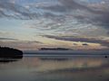
Looking West/South West With Northern End of Governor's Point and Eastern Shore of Lummi Island
-
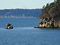
Northern End of Chuckanut Island Looking West Towards Portage Island
-
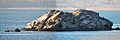
Chuckanut Rock in Western Portion of Chuckanut Bay


