
Church Run (Oil Creek tributary) facts for kids
Quick facts for kids Church Run |
|
|---|---|


|
|
| Other name(s) | Tributary to Oil Creek |
| Country | United States |
| State | Pennsylvania |
| County | Crawford |
| City | Titusville |
| Physical characteristics | |
| Main source | divide between Church Run and Thompson Creek about 2 miles north of Titusville, Pennsylvania 1,565 ft (477 m) 41°40′13″N 079°39′46″W / 41.67028°N 79.66278°W |
| River mouth | Oil Creek at Titusville, Pennsylvania Titusville, Pennsylvania 1,150 ft (350 m) 41°37′26″N 079°39′40″W / 41.62389°N 79.66111°W |
| Length | 4.0 mi (6.4 km) |
| Basin features | |
| Progression | southwest then south |
| River system | Allegheny River |
| Basin size | 4.0 square miles (10 km2) |
| Tributaries |
|
| Bridges | Church Run Road (PA 89) (x2), Union Street, W Linden Street, W Spruce Street, E Hemlock Street, N Martin Street, N Drake Street, N Kerr Street, E Main Street, E Central Avenue, E Spring Street. S Brown Street |
Church Run is a small stream, about 4 miles (6.4 km) long. It flows into Oil Creek in Crawford County, Pennsylvania. It's called a "first-order tributary" because it's one of the smallest streams that flows directly into a larger one.
Where Church Run Flows
Church Run starts about 2 miles (3.2 km) north of a town called Titusville, Pennsylvania. It begins near a natural high point that separates its water from Thompson Creek.
From its start, Church Run flows generally southwest. Then, it turns and flows south. Finally, it joins Oil Creek right in the town of Titusville.
What is a Watershed?
A watershed is like a big bowl or a drainage area. All the rain and snow that falls within this area eventually flows into one main stream or river.
Church Run's Watershed
The area that drains into Church Run is about 4.0 square miles (10.4 square kilometers). This area gets about 45 inches (114 cm) of rain and snow each year.
The average water temperature in Church Run is about 7.55 degrees Celsius (45.6 degrees Fahrenheit). A large part of the watershed, about 66%, is covered by forests. This means there are lots of trees that help keep the water clean and cool.
Images for kids
-
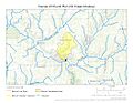
This map shows the path of Church Run and the area it drains.
.jpg)
