
Ciénega Bridge facts for kids
Quick facts for kids Ciénega Bridge |
|
|---|---|

View of the Ciénega Bridge from the top of Marsh Station Bridge, facing east. The Rincon Mountains are in the background at the left.
|
|
| Coordinates | 32°01′11″N 110°38′46″W / 32.01972°N 110.64611°W |
| Carries | Marsh Station Road, pedestrians and bicycles |
| Crosses | Ciénega Creek |
| Locale | Pima County, Arizona, United States |
| Named for | Ciénega Creek |
| Owner | Pima County |
| Inventory No. | 08293 |
| Characteristics | |
| Design | Open-spandrel arch |
| Material | Concrete |
| Pier construction | Steel |
| Total length | 277.9 ft (85 m) |
| Width | 21.7 ft (7 m) |
| Longest span | 146 ft (45 m) |
| Number of spans | 5 |
| History | |
| Designer | Merrill Butler |
| Constructed by | English and Pierce Arizona Highway Department |
| Construction begin | 1920 |
| Construction end | March 1921 |
| Construction cost | $40,000 |
| Rebuilt | 1989 (Replacement of Guardrails) |
|
Ciénega Bridge
|
|

Ciénega Bridge
Location in Arizona

Ciénega Bridge
Location in the United States
|
|
| Nearest city | Vail, Arizona |
| Area | 0.13 acres (0.053 ha) |
| Built | 1920 to 1921 |
| Built by | English and Pierce, Arizona Highway Department |
| MPS | Vehicular Bridges in Arizona MPS |
| NRHP reference No. | 88001642 |
| Added to NRHP | September 30, 1988 |
The Ciénega Bridge is a special type of bridge called an open-spandrel arch bridge. It crosses over Ciénega Creek and the Union Pacific Railroad tracks near Vail, in Arizona. This bridge was built in 1921. For many years, from 1926 to 1956, it was part of U.S. Route 80, which was a very important highway that crossed the entire United States.
The Ciénega Bridge is the oldest bridge of its kind in Arizona. Because it's so old and important, it's listed on the National Register of Historic Places. Today, the bridge is used by Marsh Station Road for cars, bikes, and people walking.
Contents
History of the Ciénega Bridge
Building a Big Bridge
In 1920, the Arizona Highway Department started building a new road in southeastern Arizona called the Borderland Highway. This highway was part of even bigger road systems like the Dixie Overland Highway and Old Spanish Trail. These were some of the first major highways that connected different parts of the country.
To build this road, they needed to cross a deep natural canyon called Ciénega Canyon. The canyon had Ciénega Creek and the Southern Pacific Railroad (now Union Pacific Railroad) running through it. State engineers decided to design a unique open-spandrel concrete arch bridge to cross this wide gap.
The main part of the bridge would be a large arch, about 146 feet (45 m) long. This arch would support the bridge deck (the part cars drive on) using concrete columns. The bridge would also have strong concrete guard rails on its sides. In total, the bridge would have five sections, including the main arch and four smaller sections leading up to it. The entire bridge would be about 278 feet (85 m) long and 23 feet (7 m) wide. Merrill Butler, a state engineer, was the main designer of this impressive bridge. They chose this spot because the strong, rocky banks of the canyon would help support the bridge.
Construction Challenges and Completion
After the design was finished, a company from Tucson called English and Pierce was chosen to build the bridge. The Highway Department provided all the building materials. The project was known as "Section F" of the Borderland Highway.
Construction began in 1920. Workers had to blast away over 900 cubic yards (688 m3) of rock to prepare the foundations for the bridge. They poured 934 cubic yards (714 m3) of concrete and used over 87,900 pounds (39,871 kg) of strong steel to reinforce it. Building the temporary supports for the arch was tricky because the creek's water levels could rise quickly.
Eventually, the Highway Department took over the rest of the construction from English and Pierce. They said the company was going over the agreed price. The Ciénega Bridge was finished in March 1921. It cost about $40,000 to build. In 1926, the Borderland Highway, including the Ciénega Bridge, became part of U.S. Route 80. This highway stretched all the way from Tybee Island, Georgia to San Diego, California.
A New Route for Safety
The Ciénega Bridge became a very busy part of US 80. By the 1950s, the road leading to the bridge was known for being quite dangerous. There was a sharp downhill curve right before the bridge. The bridge itself was high above the creek.
To make travel safer, construction started in 1952 on a new, straighter road that would bypass the old bridge. This new route included a new underpass for the railroad and two new bridges over washes. The new, safer road opened on April 9, 1955. This meant that the US 80 highway was moved to the new route, and the Ciénega Bridge was no longer part of it. The new bridge was much lower, only about 10 feet (3.0 m) above the creek, and had a straighter approach.
After the new route opened, the old Ciénega Bridge was given to Pima County. Later, in 1977, US 80 was replaced by Interstate 10. On September 30, 1988, the Ciénega Bridge was officially added to the National Register of Historic Places, recognizing its historical importance.
Most of the bridge's original structure is still the same today. The only major change was in 1989, when the old guardrails were replaced with Jersey barriers (the concrete barriers you often see on highways). Even with this change, the Ciénega Bridge remains the oldest surviving open-spandrel arch bridge in Arizona.
Gallery
-
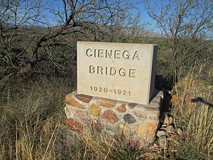
Concrete marker for Ciénega Bridge showing dates of construction.
-
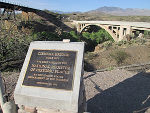
National Register of Historic Places plaque for Ciénega Bridge.
-
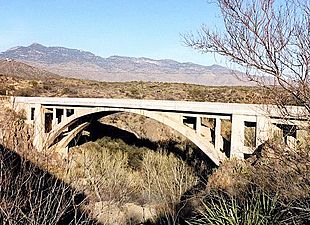
Photograph focusing on the concrete supporting arch of Ciénega Bridge.
-
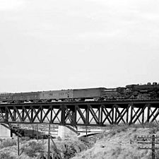
Sunset Limited of the Southern Pacific Railroad being pulled over the old EP&SW bridge with Ciénega Bridge in the background circa 1921.


