Cibecue, Arizona facts for kids
Quick facts for kids
Cibecue, Arizona
|
|
|---|---|

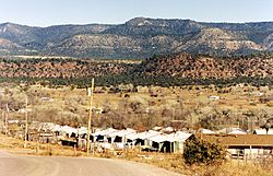
View of Cibecue
|
|

|
|
| Country | United States |
| State | Arizona |
| County | Navajo |
| Area | |
| • Total | 5.97 sq mi (15.47 km2) |
| • Land | 5.97 sq mi (15.46 km2) |
| • Water | 0.00 sq mi (0.00 km2) |
| Elevation | 4,964 ft (1,513 m) |
| Population
(2020)
|
|
| • Total | 1,816 |
| • Density | 304.14/sq mi (117.43/km2) |
| Time zone | UTC-7 (MST) |
| ZIP code |
85911
|
| Area code(s) | 928 |
| FIPS code | 04-13400 |
| GNIS feature ID | 2407619 |
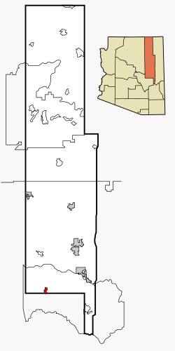
Cibecue (which means "Horizontally Red Valley/Canyon" in the Apache language) is a small community in Navajo County, Arizona, United States. It's known as a census-designated place (CDP), which is a special area defined by the government for gathering population data. Cibecue is located within the Fort Apache Indian Reservation. In 2020, about 1,816 people lived there.
The community is led by council members, who help make decisions for the area. Currently, these leaders are Arnold Beach Sr. and Tony Alsenay.
Cibecue has faced challenges, including a high rate of people not having jobs. This situation became more difficult after a very large wildfire in Arizona called the Rodeo–Chediski Fire. However, many people in Cibecue work in education, helping to teach and support the local schools.
Contents
Geography
Cibecue covers an area of about 6 square miles (15.5 square kilometers). All of this area is land, with no large bodies of water.
Climate
The weather in Cibecue changes throughout the year. Summers are generally warm, and winters are cool. The area gets some rain, especially during the summer months. Snowfall is also common in winter.
| Climate data for Cibecue, Arizona, 1914–2000 | |||||||||||||
|---|---|---|---|---|---|---|---|---|---|---|---|---|---|
| Month | Jan | Feb | Mar | Apr | May | Jun | Jul | Aug | Sep | Oct | Nov | Dec | Year |
| Mean daily maximum °F (°C) | 52.3 (11.3) |
56.5 (13.6) |
61.8 (16.6) |
70.1 (21.2) |
78.8 (26.0) |
88.5 (31.4) |
91.3 (32.9) |
88.3 (31.3) |
84.5 (29.2) |
75.0 (23.9) |
62.6 (17.0) |
54.0 (12.2) |
72.0 (22.2) |
| Mean daily minimum °F (°C) | 21.9 (−5.6) |
24.5 (−4.2) |
27.8 (−2.3) |
32.5 (0.3) |
38.2 (3.4) |
46.0 (7.8) |
56.3 (13.5) |
55.0 (12.8) |
48.3 (9.1) |
37.6 (3.1) |
26.9 (−2.8) |
23.4 (−4.8) |
36.5 (2.5) |
| Average precipitation inches (mm) | 1.83 (46) |
1.56 (40) |
1.65 (42) |
0.88 (22) |
0.46 (12) |
0.55 (14) |
2.39 (61) |
2.98 (76) |
1.80 (46) |
1.67 (42) |
1.20 (30) |
1.55 (39) |
18.52 (470) |
| Average snowfall inches (cm) | 6.3 (16) |
3.0 (7.6) |
3.4 (8.6) |
0.7 (1.8) |
0.1 (0.25) |
0.0 (0.0) |
0.0 (0.0) |
0.0 (0.0) |
0.0 (0.0) |
0.1 (0.25) |
1.6 (4.1) |
3.2 (8.1) |
18.5 (47) |
| Average precipitation days (≥ 0.01 in) | 6 | 5 | 5 | 4 | 2 | 2 | 8 | 9 | 5 | 4 | 3 | 5 | 59 |
| Source: WRCC | |||||||||||||
Demographics
Demographics is the study of a population. It looks at things like how many people live somewhere, their ages, and what languages they speak.
| Historical population | |||
|---|---|---|---|
| Census | Pop. | %± | |
| 2000 | 1,331 | — | |
| 2010 | 1,713 | 28.7% | |
| 2020 | 1,816 | 6.0% | |
| U.S. Decennial Census | |||
In 2000, there were 1,331 people living in Cibecue. Most of the people living there, about 96%, were Native American. A smaller number were White or from other backgrounds. About 2% of the population was Hispanic or Latino.
| Languages (2000) | Percent |
|---|---|
| Spoke Apache at home | 87.2% |
| Spoke English at home | 12.8% |
Many households in Cibecue had children under 18 living with them. The average household had about four people. The population in Cibecue is quite young, with a large percentage of people under the age of 18. The average age was 21 years old.
The income levels in Cibecue are generally lower than in many other parts of the United States. In 2010, Cibecue was noted as one of the places with the lowest average household income among communities with over 1,000 people.
Transportation
Getting around Cibecue and the surrounding area is possible through a few options.
Cibecue Airport
The Cibecue Airport is a small airport used for general aviation. This means it's mostly for private planes, not large commercial flights. It's located a few miles southeast of the main part of Cibecue.
Bus Service
The White Mountain Apache Tribe runs a local bus service called the Fort Apache Connection Transit. This bus helps people travel within the area.
Education
Education is very important in Cibecue. The community is served by two main school systems.
Whiteriver Unified School District
Students in Cibecue can attend schools within the Whiteriver Unified School District.
Dishchii' Bikoh Community School
There is also the Dishchii' Bikoh Community School, which is also known as the Cibecue Community School. This school serves students from kindergarten all the way through 12th grade. It's a smaller school that receives funding through grants and is managed by the Fort Apache Agency, which is part of the Bureau of Indian Affairs. The Bureau of Indian Affairs works to support Native American tribes and communities. The school has separate sections for elementary, middle, and high school students, each with its own principal.
See also
 In Spanish: Cibecue para niños


