Clarksburg, Maryland facts for kids
Quick facts for kids
Clarksburg, Maryland
|
||
|---|---|---|
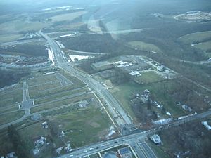
Aerial view of Clarksburg in January 2007
|
||
|
||
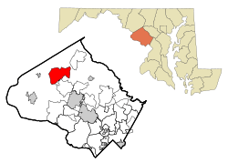
Location of Clarksburg, Maryland
|
||
| Country | ||
| State | ||
| County | ||
| Founded | 1752 | |
| Area | ||
| • Total | 9.96 sq mi (25.79 km2) | |
| • Land | 9.65 sq mi (24.99 km2) | |
| • Water | 0.31 sq mi (0.80 km2) | |
| Elevation | 551 ft (168 m) | |
| Population
(2020)
|
||
| • Total | 29,051 | |
| • Density | 3,010.78/sq mi (1,162.51/km2) | |
| Time zone | UTC−5 (Eastern (EST)) | |
| • Summer (DST) | UTC−4 (EDT) | |
| ZIP code |
20871
|
|
| Area code(s) | 301, 240 | |
| FIPS code | 24-17350 | |
| GNIS feature ID | 2389325 | |
Clarksburg is a community in northern Montgomery County, Maryland, United States. It is known as a census-designated place, which means it's a specific area the government uses for counting people. It's located at the northern end of the Interstate 270 technology corridor. This is about four miles north of Germantown. In 2020, Clarksburg had a population of 29,051 people.
Contents
History of Clarksburg
Clarksburg gets its name from a trader named John Clarke. It was founded where a main road between Georgetown and Frederick met an old Seneca trail.
One of the first European settlers was Michael Ashford Dowden. In 1752, he received land and permission to build an inn. This inn was important in history. General Edward Braddock's army stayed there during the French and Indian War. It was also a meeting spot for local Sons of Liberty before the American Revolution. These groups worked for American independence.
Around 1770, John Clarke's grandson, Jamie, built a general store. More people moved to the area, and Clark became the postmaster. By 1875, Clarksburg was a big town. However, when the Baltimore and Ohio Railroad was built, it changed the town's economy.
In 1964, planners decided Clarksburg would be the last area along Interstate 270 to have major growth. A plan was made in 1968 to build different types of homes. Another plan in 1994 aimed for the town to grow to 40,000 residents. This plan included new roads and services.
A main part of the plan was the Town Center District. This area would have shops and connect to the old business district. A shopping center with a Harris Teeter opened in 2013. A large mall called Clarksburg Premium Outlets opened in 2016. It has over 90 stores and provides many jobs.
In 2015, the Clarksburg Chamber of Commerce held a contest. They chose a flag designed by Shaneea Peek. The flag's design was inspired by Dowden's Ordinary, a historic building in Clarksburg.
Community Growth
Since the year 2000, Clarksburg has grown a lot. A new town center is being built near the historic area. In 2010, over 13,677 people lived in Clarksburg. The community has many different backgrounds and a high level of education.
New public parks and schools have been built to support the growing population.
Protecting the Environment
During the period of fast growth, some building rules were not followed. For example, some houses were built too close together. Roads were also sometimes too narrow for emergency vehicles. This happened because there wasn't enough checking by the county government.
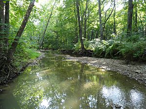
In 2014, the county council put more limits on building projects. This was to protect Tenmile Creek. This creek is an important source of drinking water for the Washington, D.C. area. Later, some developers sued the county about these limits. However, the courts decided that the county had the right to limit construction to protect the water.
Clarksburg's Geography
Clarksburg is an "unincorporated area." This means it doesn't have its own city government. Its borders are not officially set like a city's. However, the United States Census Bureau counts it as a census-designated place. This helps them collect information about the population.
Clarksburg covers about 8.3 square miles (21.5 square kilometers). Most of this area is land, with a small part being water.
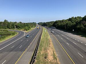
Important roads in Clarksburg include MD 355, I-270, and MD 121.
Clarksburg's Population
| Historical population | |||
|---|---|---|---|
| Census | Pop. | %± | |
| 2010 | 13,766 | — | |
| 2020 | 29,051 | 111.0% | |
| 2010–2020 | |||
In 2010, there were 13,766 people living in Clarksburg. By 2020, the population had grown to 29,051. The community is home to people from many different backgrounds.
In 2000, about 42% of households had children under 18. Most households were married couples living together. The average household had about 3 people. The population included people of all ages. About 29% were under 18, and about 8.8% were 65 or older.
Population by Race
| Race | 2010 | 2020 |
|---|---|---|
| Caucasian | 44.1% | 33.2% |
| African American | 14.7% | 18.9% |
| Native American | 0.1% | 0.6% |
| Asian | 33.6% | 38.5% |
| Other | 0.1% | - |
| Two or more Races | - | 5% |
| Hispanic | 9.8% | 10.3% |
Education in Clarksburg
Clarksburg has several schools for its students.
| School Name | Capacity | Actual Student Enrollment 2017–2018 |
Projected Student Enrollment 2018–2019 |
Percent Change
|
Percent of Capacity 2011–2012 |
|---|---|---|---|---|---|
| Clarksburg Elementary School | 589 | 312 | 410 | +76.09% | 69.60% |
| Wilson Wims Elementary | 1,399 | 752 | 1,220 | +61.63% | 53.75% |
| Little Bennett Elementary School | 685 | 624 | 614 | -1.61% | 91.09% |
| Snowden Farm Elementary | |||||
| Rocky Hill Middle School | 956 | 1,020 | 809 | -20.69% | 106.69% |
| Clarksburg High School | 1,629 | 2,034 | 2,334 | +14.74% | 124.86% |
Some schools, like Little Bennett Elementary and Clarksburg High School, have seen a big increase in students. This means they are very full. Because of this, new building permits for homes in the area have been paused. This helps manage the number of students. However, homes in projects that already started can still be built.
Parks and Recreation
Clarksburg offers many ways to have fun outdoors. You can find local hiking trails, small playgrounds, and sports fields. There are also campgrounds and community swimming pools.
Parks in the area include Little Bennett Park, Black Hill Regional Park, and Ridge Road Recreational Park. Many farms, both private and public, are also in the area. They produce food and offer fun activities for visitors.
Businesses and Organizations
Several important businesses have their main offices in Clarksburg. These include BrightFocus Foundation and Thales Communications.
Local groups that help the community include the Clarksburg Chamber of Commerce and the Clarksburg Historical Society.
See also
 In Spanish: Clarksburg (Maryland) para niños
 | Georgia Louise Harris Brown |
 | Julian Abele |
 | Norma Merrick Sklarek |
 | William Sidney Pittman |


