Clarkston, Georgia facts for kids
Quick facts for kids
Clarkston
|
||
|---|---|---|
| City of the Village of Clarkston | ||

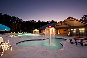
Milam Park
|
||
|
||
| Motto(s):
“Where Possibilities Grow”
|
||

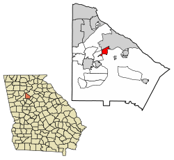
Location in DeKalb County and the state of Georgia
|
||
| Country | United States | |
| State | Georgia | |
| County | DeKalb | |
| Government | ||
| • Type | Council-Manager | |
| Area | ||
| • Total | 1.86 sq mi (4.81 km2) | |
| • Land | 1.84 sq mi (4.78 km2) | |
| • Water | 0.01 sq mi (0.04 km2) | |
| Elevation | 1,020 ft (311 m) | |
| Population
(2020)
|
||
| • Total | 14,756 | |
| • Density | 7,997.83/sq mi (3,088.40/km2) | |
| • Demonym | Clarkstonian | |
| Time zone | UTC-5 (Eastern (EST)) | |
| • Summer (DST) | UTC-4 (EDT) | |
| ZIP code |
30021
|
|
| Area code(s) | 404, 678 | |
| FIPS code | 13-16544 | |
| GNIS feature ID | 0331411 | |
Clarkston is a city located in DeKalb County, Georgia, in the United States. In 2020, about 14,756 people lived there. This was a big jump from 7,554 people in 2010.
Clarkston is famous for being a very diverse place. Some people call it "the most diverse square mile in America." It's also known as "the Ellis Island of the South." This is because many people from different countries have come to live here.
In the 1990s, programs that help people who have left their home countries found Clarkston to be a great place for them. There were many homes to rent, and it was easy to get to the city of Atlanta by public transport. Today, students at Clarkston High School come from over 50 different countries. More than half of the people living in Clarkston are estimated to have been born outside the U.S.
Contents
History of Clarkston
A post office opened in Clarkston in 1876. The state of Georgia officially made Clarkston a "Town" in 1882. The town's borders stretched half a mile around the Georgia Railroad station. The community was named after W. W. Clark, who worked for the railroad.
Geography of Clarkston
Clarkston is located at coordinates 33°48′37″N 84°14′24″W / 33.81028°N 84.24000°W.
The United States Census Bureau says that Clarkston covers about 1.1 square miles (2.8 square kilometers) in total. Most of this area is land, with a very small part being water.
Clarkston is also on the Eastern Continental Divide. This is a high point of land where water flows either east towards the Atlantic Ocean or west towards the Gulf of Mexico.
Who Lives in Clarkston?
Clarkston is known for its many different cultures and backgrounds. The city has grown a lot over the years.
| Race | Num. | Perc. |
|---|---|---|
| White (non-Hispanic) | 1,199 | 8.13% |
| Black or African American (non-Hispanic) | 9,491 | 64.32% |
| Native American | 24 | 0.16% |
| Asian | 2,866 | 19.42% |
| Pacific Islander | 7 | 0.05% |
| Other/Mixed | 620 | 4.2% |
| Hispanic or Latino | 549 | 3.72% |
In 2020, there were 14,756 people living in Clarkston. These people lived in 3,727 households, which included 2,341 families.
Schools and Learning in Clarkston
The DeKalb County School System runs the public schools in Clarkston.
Local Schools
Schools that serve students living in Clarkston include:
- Jolly, Idlewood, and Indian Creek elementary schools
- Freedom Middle School and Tucker Middle School
- Clarkston High School and Tucker High School
Even though these schools serve Clarkston, they are actually located just outside the city limits.
Other Schools and Colleges
- The Atlanta Area School for the Deaf is located within Clarkston. This school helps students who are deaf or hard of hearing.
- Georgia Fugees Academy Charter School is also in the city. It is a special type of public school.
- The Clarkston Campus of Georgia State University's Perimeter College is just south of Clarkston.
- Georgia Piedmont Technical College is also south of the city. It offers training for different jobs and careers.
Public Libraries
The DeKalb County Public Library operates the Clarkston Branch. This is where you can borrow books and use computers.
Helping Newcomers in Clarkston
Georgia is one of the states that welcomes many people who have left their home countries because of difficult situations. Since 1993, over 37,000 such people have found new homes in Georgia. Clarkston has welcomed a large number of these individuals and families.
Many organizations in Clarkston help these newcomers settle in and start new lives. These groups provide support and resources to help them feel at home.
Organizations That Help
Here are some groups that help people settle in Clarkston:
- Friends of Refugees
- Fugees Family
- International Rescue Committee of Atlanta
- New American Pathways
- World Relief Atlanta
Getting Around Clarkston
Main Roads
Clarkston has a few important roads that help people travel in and out of the city:
 US 78
US 78 SR 410
Public Transportation
Clarkston also has public buses that connect to the wider Atlanta area:
- MARTA Bus 120 connects to the MARTA Blue Line train service at Avondale.
- MARTA Bus 125 connects to the MARTA Blue Line train service at Kensington.
Walking and Biking
- The Stone Mountain Trail is a path for walking and cycling.
See also
 In Spanish: Clarkston (Georgia) para niños
 | May Edward Chinn |
 | Rebecca Cole |
 | Alexa Canady |
 | Dorothy Lavinia Brown |


