Clay City, Kentucky facts for kids
Quick facts for kids
Clay City, Kentucky
|
|
|---|---|

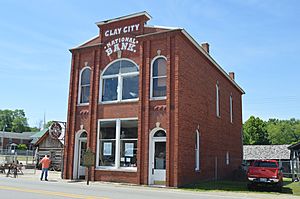
The historic Clay City National Bank Building
|
|

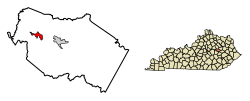
Location of Clay City in Powell County, Kentucky.
|
|
| Country | United States |
| State | Kentucky |
| County | Powell |
| Incorporated | April 19, 1890 |
| Government | |
| • Type | Mayor-Council |
| Area | |
| • Total | 1.12 sq mi (2.90 km2) |
| • Land | 1.06 sq mi (2.74 km2) |
| • Water | 0.06 sq mi (0.15 km2) |
| Elevation | 620 ft (190 m) |
| Population
(2020)
|
|
| • Total | 1,193 |
| • Density | 1,126.53/sq mi (434.88/km2) |
| Time zone | UTC-5 (Eastern (EST)) |
| • Summer (DST) | UTC-4 (EDT) |
| ZIP code |
40312
|
| Area code(s) | 606 |
| FIPS code | 21-15238 |
| GNIS feature ID | 0511380 |
Clay City is a small city in Powell County, Kentucky, United States. It is known as a home rule-class city, which means it has the power to manage its own local affairs. In 2020, about 1,193 people lived there.
Contents
History of Clay City
The first European settlers came to the Clay City area in 1786. Two brothers, Stephen Collins and his brother, found pyrite (also called "fool's gold") there. They soon built the first iron forge west of the Allegheny Mountains. This forge was a place where metal was heated and shaped. They called their settlement Collins Forge.
In 1805, the Collins brothers sold their forge. The new owners eventually formed the Red River Iron Works. For most of the 1800s, the settlement was known as Collins Forge.
Later, around the 1880s, the local post office moved across the river. It was renamed Waltersville, after a local family.
How Clay City Got Its Name
By 1883, the town was officially named Clay City. People think it was named after the clay found in the area. The post office officially changed its name to Clay City on August 13, 1883. Clay City became an official city on April 19, 1890.
Geography of Clay City
Clay City is located in a low area called the Red River Valley. Its exact location is 37°51′48″N 83°55′42″W / 37.86333°N 83.92833°W.
The United States Census Bureau says the city covers about 1.1 square miles (2.8 square kilometers). All of this area is land. Because it is so close to the Red River, the city can sometimes experience flooding when there are big storms.
Population Information
| Historical population | |||
|---|---|---|---|
| Census | Pop. | %± | |
| 1890 | 1,065 | — | |
| 1900 | 585 | −45.1% | |
| 1910 | 581 | −0.7% | |
| 1920 | 602 | 3.6% | |
| 1930 | 528 | −12.3% | |
| 1940 | 627 | 18.8% | |
| 1950 | 636 | 1.4% | |
| 1960 | 764 | 20.1% | |
| 1970 | 983 | 28.7% | |
| 1980 | 1,276 | 29.8% | |
| 1990 | 1,258 | −1.4% | |
| 2000 | 1,303 | 3.6% | |
| 2010 | 1,077 | −17.3% | |
| 2020 | 1,193 | 10.8% | |
| U.S. Decennial Census | |||
In 2000, there were 1,303 people living in Clay City. There were 543 households, which are groups of people living together. About 33% of these households had children under 18 living with them. The average age of people in the city was 34 years old.
Police Department
The Clay City Police Department (CCPD) helps keep the city safe. It is located in the Clay City Municipal Building, which is also where the city government offices are. Clay City has two full-time police officers. Other police groups, like the Powell County Sheriffs Office and the Kentucky State Police, also help out.
Things to See and Do
Clay City and the surrounding area offer several interesting places to visit:
- Furnace Mountain - This is a Zen Buddhist temple.
- Meadows Public Golf Course - A place to play golf.
- Beechfork Public Golf Course - Another golf course nearby.
- Red River Museum - A museum about the history of the Red River area.
- Meadowgreen Music Hall - A venue for music performances.
- Mountain Park Dragway - A place for drag racing events.
Climate
The weather in Clay City has hot and humid summers. The winters are usually mild to cool. This type of weather is called a humid subtropical climate. On climate maps, it is often shown as "Cfa."
See also
 In Spanish: Clay City (Kentucky) para niños
 | Audre Lorde |
 | John Berry Meachum |
 | Ferdinand Lee Barnett |

