Clayhill Brook facts for kids
Quick facts for kids Clayhill Brook |
|
|---|---|

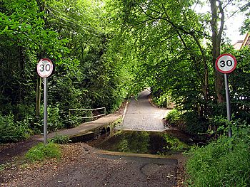
Clayhill Brook, forded at Ash Lane in Burghfield Common, Berkshire.
|
|
| Country | England |
| Counties | Berkshire |
| Districts / Boroughs | Burghfield Parish |
| Village | Burghfield Common |
| Physical characteristics | |
| Main source | Benhams Farm Burghfield Common, Burghfield Common, Berkshire, United Kingdom 95 m (312 ft) 51°23′45″N 1°04′50″W / 51.3957°N 1.0805°W |
| River mouth | The River Kennet Burghfield Mill, Burghfield, Berkshire, United Kingdom 45 m (148 ft) 51°25′57″N 1°01′54″W / 51.4324°N 1.0316°W |
Clayhill Brook is a small stream located in the county of Berkshire, England. It starts its journey at Benham's Gulley in the far west of Burghfield Common. The brook then flows through the northern edge of the village, creating a natural border between Burghfield Parish and Sulhamstead Parish. This little stream is an important home for local wildlife and eventually joins the River Kennet.
About Clayhill Brook
Clayhill Brook begins its flow at Benham's Gulley. This spot is found in the western part of Burghfield Common. As the brook moves, it helps mark the boundary between two local areas: Burghfield Parish and Sulhamstead Parish.
The brook then travels northeast. It passes through a lovely wooded area known as Omer's Gully. This woodland and the brook itself are very important for nature. They provide a safe home for many local animals and plants. It's a special place for wildlife in the area.
Further along its path, the brook reaches Ash Lane. Here, you can find a shallow crossing point called a ford. The brook continues to flow north and northeast. It goes past another woodland called Clayhill Copse. Then it flows by Stud Farm.
Near these areas, there is a facility that cleans water from local homes. This helps keep the environment healthy. The brook then goes between Burghfield Village and a small area called Trash Green. It continues northeast, passing Green Farm. It also flows under the busy M4 motorway. Finally, it goes past the gravel pits at Pingewood. The brook runs very close to Burghfield Mill. It joins the River Kennet just east of Burghfield Mill. The mill is no longer used for grinding grain. Instead, it has been turned into homes.
Water Quality of Clayhill Brook
The Environment Agency checks the water quality of rivers in England. They give each river system an overall "ecological status." This status tells us how healthy the river environment is. There are five levels: high, good, moderate, poor, and bad.
To figure out the ecological status, they look at several things.
- Biological status checks the types and numbers of living things in the water. This includes tiny creatures called invertebrates, flowering plants, and fish.
- Chemical status looks at different chemicals in the water. They compare the amounts of these chemicals to safe levels. Chemical status is either "good" or "fail."
Here's what the water quality of Clayhill Brook was like in 2019:
| Section | Ecological Status |
Chemical Status |
Overall Status |
Length | Catchment | Channel |
|---|---|---|---|---|---|---|
| Clayhill Brook | Moderate | Fail | Moderate | 5.045 km (3.135 mi) | 10.068 km2 (3.887 sq mi) |
- Ecological Status: The brook was rated "moderate." This means its environment is okay, but it could be healthier.
- Chemical Status: The brook was rated "fail." This means some chemicals in the water were above safe levels.
- Overall Status: The overall health of Clayhill Brook was "moderate."
 | George Robert Carruthers |
 | Patricia Bath |
 | Jan Ernst Matzeliger |
 | Alexander Miles |

