Clear Brook (Nanticoke River tributary) facts for kids
Quick facts for kids Clear Brook |
|
|---|---|

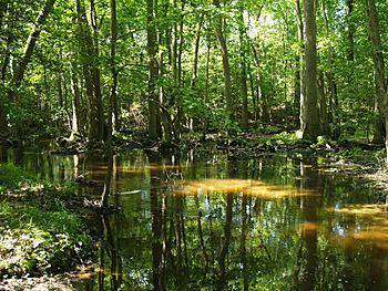
Clear Brook downstream of Hearns Pond
|
|
|
Location of Clear Brook mouth
|
|
| Other name(s) | Tributary to Nanticoke River |
| Country | United States |
| State | Delaware |
| County | Sussex |
| Physical characteristics | |
| Main source | divide between Clear Brook and Bridgeville Branch of Nanticoke River about 1 mile southwest of Bridgeville, Delaware 46 ft (14 m) 38°43′55″N 075°38′18″W / 38.73194°N 75.63833°W |
| River mouth | Nanticoke River Seaford, Delaware 0 ft (0 m) 38°38′27″N 075°36′22″W / 38.64083°N 75.60611°W |
| Length | 8.87 mi (14.27 km) |
| Basin features | |
| Progression | southeast then southwest |
| River system | Nanticoke River |
| Basin size | 23.02 square miles (59.6 km2) |
| Tributaries |
|
| Waterbodies | Hearns Pond Williams Pond |
Clear Brook is a small stream, or "brook," located in Sussex County, Delaware. It flows for about 8.87 miles (14.27 kilometers) before joining a larger river. This brook is an important part of the local water system. It helps carry water from the land into the Nanticoke River.
Contents
What is Clear Brook?
Clear Brook is a natural waterway. It is known as a "tributary" because it flows into a bigger river. In this case, it flows into the Nanticoke River. The brook is located entirely within Sussex County, Delaware.
How Long is Clear Brook?
Clear Brook is about 8.87 miles (14.27 kilometers) long. That's like walking or biking for quite a while! It's not a huge river, but it plays a big role in its local area.
Where Does Clear Brook Start and End?
Clear Brook begins southwest of a town called Bridgeville, Delaware. This starting point is about 46 feet (14 meters) above sea level. From there, the water flows downhill.
The brook then travels generally southeast. After a while, it changes direction and flows southwest. Finally, Clear Brook reaches its end point. It joins the Nanticoke River at a place called "Williams Pond." This spot is in the city of Seaford, Delaware. At this point, the water is at sea level, or 0 feet elevation.
The Water's Journey
The water in Clear Brook comes from a large area of land. This area is called its "basin" or "watershed." The Clear Brook basin covers about 23.02 square miles (59.62 square kilometers). All the rain and snow that falls in this area eventually makes its way into Clear Brook.
Other Streams Joining In
Clear Brook gets water from several smaller streams. These are also called "tributaries." On the left side of the brook, the William H. Newton Ditch adds water. On the right side, other streams join in. These include Swain and Truitt Ditch, Bucks Branch, and Herring Run.
Ponds Along the Way
As Clear Brook flows, it passes through a couple of ponds. These ponds are natural places where the water slows down. One of these is Hearns Pond. Another is Williams Pond, which is where Clear Brook meets the Nanticoke River. These ponds are important habitats for local wildlife. They also help filter the water.
 | Claudette Colvin |
 | Myrlie Evers-Williams |
 | Alberta Odell Jones |


