
Clintondale, New York facts for kids
Quick facts for kids
Clintondale, New York
|
|
|---|---|

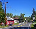
Clintondale looking east along Routes 44/55, 2007
|
|

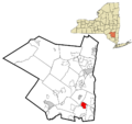
Location in Ulster County and the state of New York.
|
|
| Country | United States |
| State | New York |
| County | Ulster |
| Area | |
| • Total | 6.48 sq mi (16.77 km2) |
| • Land | 6.41 sq mi (16.59 km2) |
| • Water | 0.07 sq mi (0.18 km2) |
| Elevation | 545 ft (166 m) |
| Population
(2020)
|
|
| • Total | 1,938 |
| • Density | 302.58/sq mi (116.83/km2) |
| Time zone | UTC-5 (EST) |
| • Summer (DST) | UTC-4 (EDT) |
| ZIP code |
12515
|
| Area code(s) | 845 |
| FIPS code | 36-16452 |
| GNIS feature ID | 0946900 |
Clintondale is a small community called a hamlet in Ulster County, New York. It's also known as a census-designated place, which means it's an area the government counts for population. In 2020, about 1,938 people lived there.
Clintondale is located in the northern part of the Town of Plattekill. You can find it along US Route 44 and NY 55, where they meet County Route 22.
Contents
What is Clintondale?
Clintondale is a small community in New York State. It is not a city or a village. It is a "hamlet," which is a type of small town in New York. The government also calls it a "census-designated place" (CDP). This means it has clear borders for counting people.
When Was Clintondale Founded?
Clintondale was established a long time ago, in the year 1750. This means people started living and building a community there over 270 years ago!
Where is Clintondale Located?
Clintondale is found in Ulster County, New York. Its exact location is at coordinates 41.694548 degrees North and -74.046639 degrees West.
The community covers an area of about 5.6 square miles (14.5 square kilometers). Most of this area is land, with a very small part being water.
Who Lives in Clintondale?
The number of people living in Clintondale has changed over the years.
| Historical population | |||
|---|---|---|---|
| Census | Pop. | %± | |
| 2000 | 1,424 | — | |
| 2010 | 1,452 | 2.0% | |
| 2020 | 1,938 | 33.5% | |
| U.S. Decennial Census | |||
In 2000, there were 1,424 people living in Clintondale. These people made up 542 households. A household is a group of people living together in one home. About 346 of these households were families.
The population density was about 254.7 people per square mile. This tells us how crowded the area is. There were also 586 housing units, which are places where people can live.
Most people in Clintondale were White (about 90%). There were also people who identified as African American, Native American, Asian, Pacific Islander, and people of two or more races. About 3.65% of the population identified as Hispanic or Latino.
Many households (34.1%) had children under 18 living with them. The average household had about 2.59 people. The average family had about 3.21 people.
The age of people in Clintondale varied. About 26.5% were under 18 years old. About 9.7% were 65 years or older. The average age was 36 years old.
What About Schools in Clintondale?
Most students in Clintondale attend schools in the Highland Central School District. A smaller part of the community is served by the Marlboro Central School District.
Images for kids
-
Clintondale looking east along Routes 44/55, 2007
-
Location in Ulster County and the state of New York.
See also
 In Spanish: Clintondale para niños
