Coal Creek Historic Mining District facts for kids
Quick facts for kids |
|
|
Coal Creek Historic Mining District
|
|

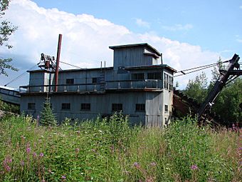
Coal Creek Dredge
|
|
| Location | Along Coal Creek, about 44 miles (71 km) southeast of Circle |
|---|---|
| Nearest city | Circle, Alaska |
| Area | 349.81 acres (141.56 ha) |
| Built | 1933 |
| Architect | Ernest N. Patty; et al. |
| MPS | Yukon River Lifeways TR |
| NRHP reference No. | 95000573 |
| Added to NRHP | May 4, 1995 |
The Coal Creek Historic Mining District is a special area in Alaska. It is found within the Yukon-Charley Rivers National Preserve. This district was a very active gold-mining site in the 1930s.
It has a huge machine called a gold dredge. This dredge was used to dig for gold. There was also a small community of buildings for the miners. A mining expert named Ernest Patty helped set up this whole operation.
Contents
Exploring the Gold Mining Area
This historic area covers the last 8 miles of Coal Creek. This creek flows into the mighty Yukon River. Near the river's mouth, you can find Slaven's Cabin, an old roadhouse.
What You Can See Today
The district shows how gold mining worked in the 1930s. You can see buildings, structures, and the big gold dredge. There are also parts of the old water system. You can even see piles of leftover rock and dirt called "tailings."
Most of the buildings were built between 1934 and 1940. They were made to be useful, not fancy. This was because the camp was far away from other towns. Everything was built to help with the mining work.
The Moving Mining Camp
The mining camp actually moved three times! It started near Cheese Creek in 1934. Then, in 1941, it moved to a hillside near Snare Creek. Finally, in 1952, it moved to its current spot at Beaton Pup.
The first camp site was dug up by the dredge. So, it doesn't exist anymore. The second site changed because the creek moved. But the third camp is still mostly there. It looks much like it did long ago.
The Frank Slaven Roadhouse is also part of this district. It's a historic building that was important for travelers.
The Giant Gold Dredge
The most important machine in the district is the gold dredge. It's a large, floating machine powered by diesel fuel. It was used to scoop up gravel from the creek bed. This gravel was then processed to find gold.
How the Dredge Arrived
This huge dredge was built far away in Oakland, California. It was taken apart into many pieces. Then, it was shipped all the way to Skagway, Alaska. From there, it traveled by train to Whitehorse, Yukon Territory. Finally, it was floated down the Yukon River on barges. Imagine how much work that took!
The Man Behind the Mine: Ernest Patty
The gold mining operation at Coal Creek was managed by Ernest Patty. He was a mining engineer. He first came to Alaska in 1922. He even taught at the University of Alaska in Fairbanks.
Later, Ernest Patty became the president of the University of Alaska in 1953. He retired from that job in 1960. He played a big role in both mining and education in Alaska.
Important Places in the District
Many different parts make up this historic mining district. Here are some of the key places:
- The Slaven's Cabin, 65°21′02″N 143°07′22″W / 65.35045°N 143.12267°W, built between 1928 and 1930.
- The old road along Coal Creek, 65°18′32″N 143°08′56″W / 65.30876°N 143.14876°W.
- The piles of leftover rock from mining, called "trailing piles," 65°19′26″N 143°07′02″W / 65.32394°N 143.11714°W.
- The big gold dredge itself, 65°20′05″N 143°06′51″W / 65.3347°N 143.11423°W, built in 1935.
- The main Coal Creek Mining Camp, 65°18′19″N 143°09′14″W / 65.30522°N 143.15401°W, which has 21 buildings built from 1936 to 1941.
- The remains of cabins along Snare Creek, 65°18′05″N 143°11′02″W / 65.30127°N 143.184°W.
- The ditch, 65°16′58″N 143°14′06″W / 65.28266°N 143.23508°W, and where it meets Coal Creek 65°16′22″N 143°17′06″W / 65.27284°N 143.28508°W, both built in 1935.
- The Cheese Creek Camp, 65°17′02″N 143°12′40″W / 65.28397°N 143.21113°W, built between 1936 and 1941.
 | May Edward Chinn |
 | Rebecca Cole |
 | Alexa Canady |
 | Dorothy Lavinia Brown |


