
Circle, Alaska facts for kids
Quick facts for kids
Circle
Danzhit Khànląįį
|
|
|---|---|
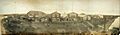
.jpg)
View of circle in 1941
|
|

Location of Circle, Alaska
|
|
| Country | United States |
| State | Alaska |
| Census Area | Yukon-Koyukuk |
| Area | |
| • Total | 106.58 sq mi (276.04 km2) |
| • Land | 106.04 sq mi (274.64 km2) |
| • Water | 0.54 sq mi (1.40 km2) |
| Population
(2020)
|
|
| • Total | 91 |
| • Density | 0.86/sq mi (0.33/km2) |
| Time zone | UTC-9 (Alaska (AKST)) |
| • Summer (DST) | UTC-8 (AKDT) |
| ZIP code |
99733
|
| Area code(s) | 907 |
| FIPS code | 02-14880 |

Circle (also known as Circle City) is a small community in Alaska, United States. It is called a census-designated place (CDP). This means it is a place that the government counts for the census, but it is not officially a city or town.
Circle is located about 160 miles (257 km) northeast of Fairbanks. It sits at the end of the Steese Highway along the Yukon River. Miners in the late 1800s named the town "Circle" because they thought it was on the Arctic Circle. However, the Arctic Circle is actually about 50 miles (80 km) north of Circle.
In the past, Circle was a busy place for moving goods along the Yukon River. Today, it is much smaller. The population was 91 people in 2020. Most of the people living in Circle today are Athabascan.
Contents
Life in Circle
Circle is a very remote place. There is only one general store, called Hutchinson Commercial. This store sells food, other goods, and is the only place to get fuel in town. Fuel prices are usually much higher than in Fairbanks.
Every February, Circle City is a stop for the famous Yukon Quest sled dog race. This is a very long race that covers 1,000 miles (1,600 km) across Alaska and Canada.
Geography and Climate
Circle is located at 65°50′4″N 144°4′35″W. The area of Circle is about 108 square miles (280 square kilometers). Most of this area is land, with a small amount of water.
Weather in Circle
Circle has a subarctic climate. This means it has very long, cold winters and short, cool summers.
- Winter: Winters are extremely cold. The coldest temperature ever recorded was -60°F (-51°C).
- Summer: Summers are mild, but can have hot days. The hottest temperature ever recorded was 94°F (34°C).
- Snow: Circle gets a lot of snow, especially in the winter months.
- Rain: Most of the rain falls during the summer.
History of Circle
Circle was founded in 1893. This happened after gold was found in a nearby area called Birch Creek. The town became a key spot for unloading supplies. These supplies were shipped up the Yukon River from the Bering Sea. From Circle, the goods were then sent over land to the gold mining camps.
In 1896, before the famous Klondike Gold Rush, Circle was the biggest mining town on the Yukon River. It had about 700 people living there. The town had many important buildings and services:
- A store
- Dance halls
- An opera house
- A library and a school
- A hospital and a church
- A newspaper and a mill
- Several government officials, like a postmaster
Circle's population dropped a lot after new gold discoveries in the Klondike in 1897 and Nome in 1899. Many miners left Circle to seek gold in these new places. However, some miners stayed near Circle, and gold mining has continued in the area into the 21st century.
Education
The Yukon Flats School District is in charge of the school in Circle.
Images for kids
-
Panoramic view of Circle's main street in September 1899.
-

A panoramic view of Circle, Alaska, on August 6, 2008. The Yukon River is on the far right.
See also
 In Spanish: Circle (Alaska) para niños
