Coca de Alba facts for kids
Quick facts for kids
Coca de Alba
|
|||
|---|---|---|---|
|
municipality
|
|||
|
|||

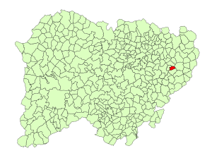
Location in Salamanca
|
|||
| Country | Spain | ||
| Autonomous community | Castile and León | ||
| Province | Salamanca | ||
| Comarca | Tierra de Alba | ||
| Area | |||
| • Total | 10 km2 (4 sq mi) | ||
| Elevation | 837 m (2,746 ft) | ||
| Population
(2018)
|
|||
| • Total | 108 | ||
| • Density | 11/km2 (28/sq mi) | ||
| Time zone | UTC+1 (CET) | ||
| • Summer (DST) | UTC+2 (CEST) | ||
| Postal code |
37830
|
||
Coca de Alba is a small town, also known as a municipality, located in western Spain. It is part of the Salamanca province, which is in the Castile and León region. This charming place is about 35 kilometers (22 miles) away from Salamanca, the main city of the province. As of 2018, about 108 people live in Coca de Alba.
Contents
Exploring Coca de Alba's Location
Coca de Alba is situated in a beautiful part of Spain. Understanding its geography helps us learn more about this small community.
Where is Coca de Alba Located?
This municipality covers an area of 10 square kilometers (about 3.86 square miles). To give you an idea, that's roughly the size of 1,400 football fields! It sits 837 meters (2,746 feet) above sea level. This means it's quite high up, which can affect its weather and landscape. The postal code for Coca de Alba is 37830.
Government and Leadership
Like all towns, Coca de Alba has a local government. The leader of the municipality is called the Mayor. The current Mayor is Antonio González Sánchez, who belongs to the People's Party. The Mayor and the local council work together to make decisions for the community. They manage things like local services and town planning.
See also
 In Spanish: Coca de Alba para niños
 | James Van Der Zee |
 | Alma Thomas |
 | Ellis Wilson |
 | Margaret Taylor-Burroughs |


