
Coimbatore District (Madras Presidency) facts for kids
Coimbatore district was a large area in British India. It was part of the Madras Presidency. This district included places that are now Coimbatore, Erode, and Tirupur districts. It also covered the Kollegal area, which is now in Karnataka. The district was huge, about 20,400 square kilometers (about 7,860 square miles). It was split into 10 smaller parts called taluks. The main city and administrative center was Coimbatore city. Most people spoke Tamil, but many also spoke Malayalam, Telugu, and Kannada.
History of Coimbatore District
Coimbatore was once part of the ancient Chera kingdom. This was during a time known as the Sangam Age. After the Chera kingdom ended, other groups took control. These included the Western Gangas and the Hoysalas.
In the 13th century AD, Coimbatore came under Muslim rule. It then became a part of the powerful Vijayanagar Empire. After this empire fell, the Madurai Nayaks ruled Coimbatore until the 17th century.
Later, there were many wars between the Kingdom of Mysore and the Madurai Nayak dynasty. Because of these wars, the Mysore kings gained control of the region. This lasted until 1792. In that year, Tipu Sultan was defeated in the Third Mysore War. After this, Coimbatore became a part of British India.
The Coimbatore district was officially created in 1805. Over time, its borders changed. In 1868, the Nilgiri District was separated from it. The Avinashi taluk was formed later. This happened when Karur was removed from Coimbatore district and joined with Trichinopoly District. More changes to the district's size were made in 1927 and 1929. Finally, in 1956, the Kollegal taluk was moved to Mysore State.
Images for kids
-
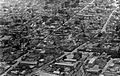
Aerial view of the Coimbatore Townhall area in 1930
-
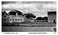
View of the Coimbatore Stanes Coffee Curing Works in 1911


