Colón, Venezuela facts for kids
Quick facts for kids
San Juan de Colón
|
|||
|---|---|---|---|

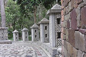
Castle in Colón.
|
|||
|
|||
| Nickname(s):
"La Ciudad de Las Palmeras"
(English:"The Palm City") |
|||
| Country | Venezuela | ||
| State | Táchira | ||
| Municipality | Ayacucho | ||
| Area | |||
| • Total | 484 km2 (187 sq mi) | ||
| Elevation | 850 m (2,790 ft) | ||
| Population
(2013)
|
|||
| • Total | 36,925 | ||
| • Density | 76.29/km2 (197.59/sq mi) | ||
| Time zone | UTC−4 (VET) | ||
| Area code(s) | 0277 | ||
| Climate | Am | ||
| Website | ayacucho-tachira.gob.ve | ||
| The area and population figures are for the municipality | |||
Colón is a town located in the Andes mountains of Venezuela. It is part of the Táchira state. This town is the main center, or "shire town," of the Ayacucho Municipality. In 2001, a count of people (called a census) showed that the municipality had about 48,982 residents.
Contents
What is the Climate Like in Colón?
Colón has a tropical rainforest climate. This means it's warm all year round. The average high temperature is about 26.1 degrees Celsius (79 degrees Fahrenheit). The average low temperature is around 20.2 degrees Celsius (68.4 degrees Fahrenheit).
The town gets a lot of rain throughout the year. The rainiest months are usually October and November. On average, Colón receives about 1485.9 millimeters (58.50 inches) of rain each year.
| Climate data for Colón (1991–2020) | |||||||||||||
|---|---|---|---|---|---|---|---|---|---|---|---|---|---|
| Month | Jan | Feb | Mar | Apr | May | Jun | Jul | Aug | Sep | Oct | Nov | Dec | Year |
| Record high °C (°F) | 33.6 (92.5) |
32.5 (90.5) |
36.5 (97.7) |
33.1 (91.6) |
33.6 (92.5) |
33.6 (92.5) |
35.0 (95.0) |
37.1 (98.8) |
34.4 (93.9) |
34.6 (94.3) |
34.4 (93.9) |
31.5 (88.7) |
37.1 (98.8) |
| Mean daily maximum °C (°F) | 25.3 (77.5) |
25.3 (77.5) |
25.5 (77.9) |
26.0 (78.8) |
26.5 (79.7) |
26.7 (80.1) |
26.6 (79.9) |
27.2 (81.0) |
27.2 (81.0) |
26.2 (79.2) |
25.4 (77.7) |
25.1 (77.2) |
26.1 (79.0) |
| Daily mean °C (°F) | 22.1 (71.8) |
22.3 (72.1) |
22.8 (73.0) |
23.1 (73.6) |
23.4 (74.1) |
23.3 (73.9) |
23.2 (73.8) |
23.6 (74.5) |
23.4 (74.1) |
23.0 (73.4) |
22.5 (72.5) |
22.2 (72.0) |
22.9 (73.2) |
| Mean daily minimum °C (°F) | 19.2 (66.6) |
19.4 (66.9) |
19.8 (67.6) |
20.5 (68.9) |
20.7 (69.3) |
20.7 (69.3) |
20.5 (68.9) |
20.7 (69.3) |
20.5 (68.9) |
20.3 (68.5) |
20.0 (68.0) |
19.7 (67.5) |
20.2 (68.4) |
| Record low °C (°F) | 15.2 (59.4) |
14.4 (57.9) |
15.8 (60.4) |
14.9 (58.8) |
14.9 (58.8) |
15.7 (60.3) |
15.7 (60.3) |
12.0 (53.6) |
13.8 (56.8) |
11.3 (52.3) |
13.2 (55.8) |
15.6 (60.1) |
11.3 (52.3) |
| Average precipitation mm (inches) | 94.9 (3.74) |
81.3 (3.20) |
119.5 (4.70) |
165.4 (6.51) |
122.6 (4.83) |
86.6 (3.41) |
84.9 (3.34) |
86.0 (3.39) |
118.6 (4.67) |
188.2 (7.41) |
203.9 (8.03) |
134.0 (5.28) |
1,485.9 (58.50) |
| Average precipitation days (≥ 1.0 mm) | 6.7 | 7.5 | 10.1 | 13.1 | 12.3 | 10.8 | 10.7 | 10.4 | 11.8 | 14.8 | 14.0 | 9.8 | 132.0 |
| Source: NOAA | |||||||||||||
Who Lives in Ayacucho Municipality?
The Ayacucho Municipality is where Colón is located. In 2001, the population was 48,982 people. This was an increase from 41,404 people in 1990. This means that about 4.9% of all the people in Táchira state live in this municipality. The municipality has about 101.20 people living in each square kilometer (or 262.1 people per square mile).
Places to Visit
Colón has some interesting places to see.
Religious Buildings
- Iglesia San Juan Bautista (Saint John the Baptist Church)
Squares and Parks
- Plaza Bolívar
- Plaza Sucre de Colón
Famous People from Colón
Some well-known people have come from Colón:
- Ramón José Velásquez: He was a former interim president of Venezuela. An interim president is someone who takes over the job for a short time.
- Pedro Antonio Ríos Reyna: He was a famous Venezuelan classical musician.
See also
 In Spanish: San Juan de Colón para niños


