Colden, New York facts for kids
Quick facts for kids
Colden
|
|
|---|---|
| Town of Colden | |

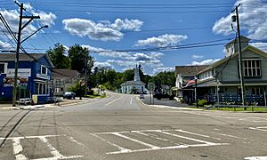
Town center, July 2021
|
|

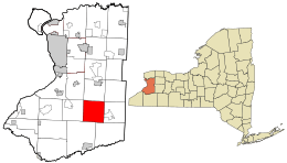
Location in Erie County and the state of New York
|
|

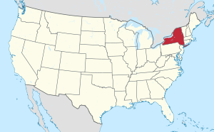
Location of New York in the United States
|
|
| Country | United States |
| State | New York |
| County | Erie |
| Incorporated | 1827 |
| Named for | Cadwallader D. Colden |
| Area | |
| • Total | 35.72 sq mi (92.52 km2) |
| • Land | 35.63 sq mi (92.29 km2) |
| • Water | 0.09 sq mi (0.23 km2) |
| Elevation | 1,183 ft (361 m) |
| Population
(2010)
|
|
| • Total | 3,333 |
| • Estimate
(2018)
|
3,308 |
| • Density | 92.84/sq mi (35.84/km2) |
| Time zone | UTC-5 (EST) |
| • Summer (DST) | UTC-4 (EDT) |
| ZIP code |
14033
|
| Area code(s) | 716 |
| FIPS code | 36-029-16870 |
Colden is a small town in Erie County, New York. In 2010, about 3,265 people lived there. The town is named after Cadwallader D. Colden, who was a state senator. Colden is located in the southeastern part of Erie County. It is known as one of the "Southtowns" in the area.
Contents
History of Colden
The town of Colden was officially created on April 2, 1827. It was formed from a part of the nearby town of Holland. One of the very first people to settle here was Richard Buffum. He came from Rhode Island. Richard Buffum bought a large area of land, about 2,000 acres, from the Holland Land Company.
Geography of Colden
Colden covers a total area of about 92.5 square kilometers. Most of this area, about 92.3 square kilometers, is land. Only a small part, about 0.2 square kilometers, is water. This means Colden is mostly land-based.
A major road, New York State Route 240, runs through the southwestern part of the town. This road helps people travel through Colden.
Climate in Colden
| Climate data for Colden, New York, 1970–2000 normals, extremes 1957-2002 | |||||||||||||
|---|---|---|---|---|---|---|---|---|---|---|---|---|---|
| Month | Jan | Feb | Mar | Apr | May | Jun | Jul | Aug | Sep | Oct | Nov | Dec | Year |
| Record high °F (°C) | 65 (18) |
70 (21) |
80 (27) |
91 (33) |
89 (32) |
96 (36) |
96 (36) |
95 (35) |
92 (33) |
84 (29) |
77 (25) |
72 (22) |
96 (36) |
| Mean maximum °F (°C) | 52 (11) |
55 (13) |
67 (19) |
79 (26) |
83 (28) |
87 (31) |
88 (31) |
87 (31) |
84 (29) |
77 (25) |
67 (19) |
56 (13) |
89 (32) |
| Mean daily maximum °F (°C) | 30.2 (−1.0) |
32.9 (0.5) |
41.5 (5.3) |
54.4 (12.4) |
66.8 (19.3) |
75.5 (24.2) |
79.2 (26.2) |
77.9 (25.5) |
70.4 (21.3) |
59.1 (15.1) |
46.6 (8.1) |
35.5 (1.9) |
55.8 (13.2) |
| Daily mean °F (°C) | 21.8 (−5.7) |
23.2 (−4.9) |
31.4 (−0.3) |
43.3 (6.3) |
54.4 (12.4) |
63.9 (17.7) |
67.7 (19.8) |
66.6 (19.2) |
59.2 (15.1) |
48.3 (9.1) |
38.4 (3.6) |
28.0 (−2.2) |
45.5 (7.5) |
| Mean daily minimum °F (°C) | 13.3 (−10.4) |
13.5 (−10.3) |
21.3 (−5.9) |
32.3 (0.2) |
42.2 (5.7) |
52.3 (11.3) |
56.4 (13.6) |
55.2 (12.9) |
48.2 (9.0) |
37.6 (3.1) |
30.2 (−1.0) |
20.5 (−6.4) |
35.3 (1.8) |
| Mean minimum °F (°C) | −10 (−23) |
−10 (−23) |
−2 (−19) |
18 (−8) |
28 (−2) |
36 (2) |
44 (7) |
43 (6) |
32 (0) |
24 (−4) |
13 (−11) |
−2 (−19) |
−14 (−26) |
| Record low °F (°C) | −24 (−31) |
−30 (−34) |
−18 (−28) |
4 (−16) |
21 (−6) |
28 (−2) |
37 (3) |
30 (−1) |
24 (−4) |
14 (−10) |
−3 (−19) |
−25 (−32) |
−30 (−34) |
| Average precipitation inches (mm) | 3.68 (93) |
2.82 (72) |
3.58 (91) |
3.76 (96) |
3.63 (92) |
4.32 (110) |
3.99 (101) |
4.19 (106) |
4.93 (125) |
3.98 (101) |
4.68 (119) |
4.44 (113) |
48 (1,219) |
| Average snowfall inches (cm) | 45.5 (116) |
28.0 (71) |
19.1 (49) |
5.9 (15) |
0.2 (0.51) |
0.0 (0.0) |
0.0 (0.0) |
0.0 (0.0) |
0.0 (0.0) |
0.6 (1.5) |
16.9 (43) |
40.1 (102) |
156.3 (398.01) |
| Average extreme snow depth inches (cm) | 20 (51) |
18 (46) |
12 (30) |
3 (7.6) |
0.0 (0.0) |
0.0 (0.0) |
0.0 (0.0) |
0.0 (0.0) |
0.0 (0.0) |
0.0 (0.0) |
8 (20) |
14 (36) |
24 (61) |
| Source: NOAA | |||||||||||||
Population and People of Colden
| Historical population | |||
|---|---|---|---|
| Census | Pop. | %± | |
| 1830 | 464 | — | |
| 1840 | 1,088 | 134.5% | |
| 1850 | 1,344 | 23.5% | |
| 1860 | 1,568 | 16.7% | |
| 1870 | 1,472 | −6.1% | |
| 1880 | 1,464 | −0.5% | |
| 1890 | 1,378 | −5.9% | |
| 1900 | 1,260 | −8.6% | |
| 1910 | 1,303 | 3.4% | |
| 1920 | 1,259 | −3.4% | |
| 1930 | 1,217 | −3.3% | |
| 1940 | 1,528 | 25.6% | |
| 1950 | 1,720 | 12.6% | |
| 1960 | 2,384 | 38.6% | |
| 1970 | 3,020 | 26.7% | |
| 1980 | 3,128 | 3.6% | |
| 1990 | 2,899 | −7.3% | |
| 2000 | 3,323 | 14.6% | |
| 2010 | 3,265 | −1.7% | |
| 2016 (est.) | 3,308 | 1.3% | |
| U.S. Decennial Census | |||
In 2000, there were 3,323 people living in Colden. These people lived in 1,262 households. About 951 of these were families. The town had about 93 people per square mile. There were 1,337 homes in total.
Most of the people in Colden were White (98.83%). A very small number were African American (0.03%), Native American (0.21%), or Asian (0.18%). Some people were from other backgrounds (0.09%) or mixed races (0.66%). About 0.42% of the population was Hispanic or Latino.
About 32.4% of households had children under 18 living with them. Most households (63.7%) were married couples. About 7.8% were single mothers. Nearly a quarter (24.6%) were not families. Many people (18.7%) lived alone. About 6.2% of homes had someone 65 or older living by themselves. The average household had 2.63 people. The average family had 3.01 people.
The population was spread out by age. About 24.9% were under 18. About 29.9% were between 25 and 44. The median age was 40 years old. For every 100 females, there were about 102.6 males.
In 2000, the average income for a household was $47,230. For families, it was $52,460. The average income per person in the town was $22,510. A small number of families (2.7%) and people (3.4%) lived below the poverty line. This included 3.0% of those under 18. It also included 1.8% of those 65 or older.
Places and Communities in Colden
- Buffalo Ski Club – This is a ski resort. It used to include the Tamarack Ski resort and the Sitzmarker Area. It's owned by its members but is open to everyone.
- Buffums Mills – This is a place in Colden with a lot of history.
- Colden – This is the main hamlet (small village) of Colden. It's in the western part of the town, along NY-240.
- Glenwood – Another hamlet located south of the main Colden hamlet. It is also on NY-240.
- Kissing Bridge – This is another popular ski resort. It is also located on NY-240.
Interesting Sights in Colden
- WIVB-TV Tower – This is a very tall TV tower. It is one of the oldest supertall TV towers in the United States.
Notable People from Colden
- Tim Bender – A famous snowmobile rider. He is in the Snowmobile Hall of Fame. He also used to be a NASCAR driver.
- John M. Wiley – He was a former US congressman.
See also
 In Spanish: Colden (Nueva York) para niños
 | Bayard Rustin |
 | Jeannette Carter |
 | Jeremiah A. Brown |

