Coleridge, Nebraska facts for kids
Quick facts for kids
Coleridge, Nebraska
|
|
|---|---|
|
Village
|
|

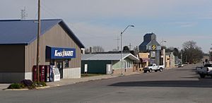
Downtown Coleridge on Broadway
|
|
| Nickname(s):
Heart of Cedar County
|
|

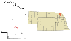
Location of Coleridge, Nebraska
|
|
| Country | United States |
| State | Nebraska |
| County | Cedar |
| Area | |
| • Total | 0.51 sq mi (1.32 km2) |
| • Land | 0.51 sq mi (1.32 km2) |
| • Water | 0.00 sq mi (0.00 km2) |
| Elevation | 1,555 ft (474 m) |
| Population
(2020)
|
|
| • Total | 537 |
| • Estimate
(2021)
|
533 |
| • Density | 1,053/sq mi (406.8/km2) |
| Time zone | UTC-6 (Central (CST)) |
| • Summer (DST) | UTC-5 (CDT) |
| ZIP code |
68727
|
| Area code(s) | 402 |
| FIPS code | 31-09865 |
| GNIS feature ID | 2398596 |
| Website | coleridge-ne.com |
Coleridge is a small village located in Cedar County, Nebraska, in the United States. In 2020, about 537 people lived there.
Contents
History of Coleridge
Coleridge was officially planned and laid out in 1883. This happened when the railroad lines were extended to this area. The village was named after Lord John Coleridge. He was a very important judge from England who was visiting the United States at that time.
Originally, the railroad company wanted to build tracks through a nearby town called Norris. However, they couldn't agree on a path with Mr. Norris, who owned land there. So, the railroad was built about two miles west of Norris instead. This new area became Coleridge.
Soon, many businesses from Norris moved to Coleridge. By 1885, Coleridge was growing, and Norris became much smaller. The Norris School even joined with Coleridge's school district in 1959.
Tornadoes in Coleridge
Coleridge has experienced some strong storms. On June 23, 2003, a very powerful tornado, known as an F4, hit the area. It caused a lot of damage to homes and farms. Sadly, one person died during this storm.
Another large tornado, an EF3, came close to Coleridge on June 17, 2014. This tornado mainly traveled north of the village. It destroyed two farmhouses and snapped many trees. Even a scoreboard and bleachers were swept away. Luckily, no one was hurt during this tornado.
Geography of Coleridge
Coleridge is a small village that covers about 0.51 square miles (1.32 square kilometers). All of this area is land; there are no large bodies of water within the village limits.
People of Coleridge
Understanding the people who live in a place is called demographics. Here's how the population of Coleridge has changed over the years:
| Historical population | |||
|---|---|---|---|
| Census | Pop. | %± | |
| 1890 | 315 | — | |
| 1900 | 471 | 49.5% | |
| 1910 | 535 | 13.6% | |
| 1920 | 674 | 26.0% | |
| 1930 | 616 | −8.6% | |
| 1940 | 627 | 1.8% | |
| 1950 | 621 | −1.0% | |
| 1960 | 604 | −2.7% | |
| 1970 | 608 | 0.7% | |
| 1980 | 673 | 10.7% | |
| 1990 | 596 | −11.4% | |
| 2000 | 541 | −9.2% | |
| 2010 | 473 | −12.6% | |
| 2020 | 537 | 13.5% | |
| U.S. Decennial Census | |||
In 2010, there were 473 people living in Coleridge. These people lived in 224 households. About 18% of the residents were under 18 years old. Many people in Coleridge are older, with about 31.9% being 65 years or older. The average household had about 2 people.
Famous People from Coleridge
Some notable people have come from Coleridge:
- William Joseph Dendinger (born 1939), a Roman Catholic bishop.
- Vernon Simeon Plemion Grant (1902–1990), a well-known illustrator.
- George Stone (1876–1945), a professional baseball player. He was a Major League Baseball left fielder and won the batting championship in 1906.
See also
 In Spanish: Coleridge (Nebraska) para niños
 | Lonnie Johnson |
 | Granville Woods |
 | Lewis Howard Latimer |
 | James West |

