Coles Brook facts for kids
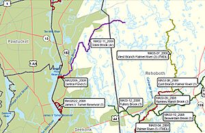
Coles Brook is a small stream in Massachusetts. It starts near Pine Street in Rehoboth. From there, it flows southwest. The brook eventually reaches Central Pond and the James V. Turner Reservoir. These are located right on the border of Seekonk, Massachusetts and East Providence, Rhode Island. Coles Brook is a smaller stream that flows into the Ten Mile River.
This brook is about 4.4 miles (7.1 kilometers) long. Along its path, you can find three small dams. The brook also flows through a special place called the Caratunk wildlife reservation in Seekonk. This area has lots of open space and is home to many wild animals. It's also a historic spot where Native American camps once stood. People have even found old artifacts there!
Coles Brook is listed by the EPA. This means it has some issues with cleanliness, mainly due to tiny germs called pathogens. However, it's still considered a Class B waterway. This rating means the water is generally good enough for fish to live in and for people to swim in.
What Feeds Coles Brook?
Coles Brook gets its water from a few smaller streams. The main ones are Dry Brook, Cascading Brook, and Muskrat Brook. Several other small streams also add water to Coles Brook as it flows along.
Where Coles Brook Flows Under Roads
As Coles Brook travels, it passes under several roads. Here are some of the places it crosses, starting from where it begins:
- In Rehoboth:
- Homestead Avenue
- Sweeney Road
- In Seekonk:
- Pine Street
- Fairway Drive
- Tompson Drive
- Newman Avenue (MA 152)


