
Colombian Massif facts for kids
Quick facts for kids Colombian Massif |
|
|---|---|

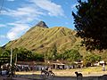
Puracé Volcano
|
|
| Highest point | |
| Peak | Puracé |
| Elevation | 4,646 m (15,243 ft) |
| Dimensions | |
| Area | 32,682 km2 (12,619 sq mi) |
| Geography | |

Colombian Massif
Location in Colombia
|
|
| Country | Colombia |
| State/Province | Cauca, Huila, Nariño |
The Colombian Massif, also called Macizo Colombiano, is a big group of mountains. It's part of the Andes mountain range in south-central Colombia. This area is mostly in the Cauca, Huila, and Nariño Departments. To its south is the Pasto Massif. To its north, the Central and Eastern Andes begin.
Contents
What is the Colombian Massif?
The Colombian Massif covers a huge area of about 32,682 km2 (12,619 sq mi). A large part of it is covered by forests. Other areas include farms (called agroecosystems) and special high-altitude grasslands called páramos. There's even a small snowy area. The land here goes from about 2,600 m (8,500 ft) high to 4,646 m (15,243 ft) high.
Why is the Colombian Massif Important?
This mountain area is super important for Colombia. It's where 70% of the country's freshwater comes from. This water is used by people for drinking and for watering crops.
Rivers that Start Here
Many big rivers begin in the Colombian Massif. These include the Magdalena and Cauca Rivers. These rivers flow towards the Caribbean Sea. The Caquetá and Putumayo Rivers also start here. They flow into the huge Amazon basin. The Patía River begins here too, flowing towards the Pacific Ocean.
Nature and Wildlife
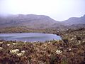
The massif has 362 high mountain lakes and 13 páramos. These are special ecosystems with lots of different plants and animals. Some of the páramos include Cutanga, Letero, Las Papas (Potatoes), Apio (Celery), and Buey (Ox).
There are also high valleys like the Valley of Potatoes and Valley of Paletara. The Sotará and Puracé are the main volcanoes in this area. The Puracé volcano is inside the Puracé National Natural Park.
Exploring the Massif
Not many people have traveled through all the mountains here. The land is very rough and the páramo areas are cold and hard to get through. These natural features help protect the water sources. These sources provide water for half of Colombia before the rivers flow into the sea.
Images for kids
-
Cerro de Lerma
in Cauca -
Las Reginas


See also
 In Spanish: Macizo Colombiano para niños
