Colomby-Anguerny facts for kids
Quick facts for kids
Colomby-Anguerny
|
|
|---|---|

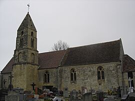
The church in Anguerny
|
|
| Country | France |
| Region | Normandy |
| Department | Calvados |
| Arrondissement | Caen |
| Canton | Courseulles-sur-Mer |
| Area
1
|
5.61 km2 (2.17 sq mi) |
| Population
(2021)
|
1,306 |
| • Density | 232.80/km2 (602.9/sq mi) |
| Time zone | UTC+01:00 (CET) |
| • Summer (DST) | UTC+02:00 (CEST) |
| INSEE/Postal code |
14014 /14610
|
| 1 French Land Register data, which excludes lakes, ponds, glaciers > 1 km2 (0.386 sq mi or 247 acres) and river estuaries. | |
Colomby-Anguerny is a small town, also called a commune, located in northwestern France. It is part of the Calvados area, which is one of the many departments in France.
This commune was officially created on January 1, 2016. It was formed by joining two older communes: Colomby-sur-Thaon and Anguerny. This means the two smaller towns became one larger administrative area.
About Colomby-Anguerny
Colomby-Anguerny is found in the Caen area, known as an arrondissement. It is also part of the Courseulles-sur-Mer canton, which is another way France organizes its local areas.
Population and Leadership
As of 2021, about 1,306 people live in Colomby-Anguerny. The town is led by a mayor, who is like a local president. The current mayor is Jean-Luc Guillouard, and his term is from 2020 to 2026. The mayor helps manage the town's services and represents its people.
Geography and Location
The commune covers an area of 5.61 square kilometers. Its exact location can be found using coordinates: 49.266 degrees North and 0.404 degrees West. This helps people find it on a map.
More Information
- If you want to learn more about Colomby-Anguerny in Spanish, you can visit this page: Colomby-Anguerny para niños


