Anguerny facts for kids
Quick facts for kids
Anguerny
|
||
|---|---|---|
|
Part of Colomby-Anguerny
|
||

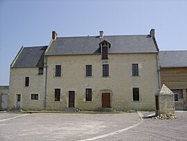
Old House at Anguerny
|
||
|
||
| Country | France | |
| Region | Normandy | |
| Department | Calvados | |
| Arrondissement | Caen | |
| Canton | Courseulles-sur-Mer | |
| Commune | Colomby-Anguerny | |
| Area
1
|
2.85 km2 (1.10 sq mi) | |
| Population
(2013)
|
754 | |
| • Density | 264.6/km2 (685.2/sq mi) | |
| Time zone | UTC+01:00 (CET) | |
| • Summer (DST) | UTC+02:00 (CEST) | |
| Postal code |
14610
|
|
| Elevation | 44–69 m (144–226 ft) (avg. 49 m or 161 ft) |
|
| 1 French Land Register data, which excludes lakes, ponds, glaciers > 1 km2 (0.386 sq mi or 247 acres) and river estuaries. | ||
Anguerny (French pronunciation: [ɑ̃ɡɛʁni]) was once a small town in the Calvados area of Normandy, a region in northwestern France. On January 1, 2016, Anguerny joined with another town to form a new, larger town called Colomby-Anguerny.
Contents
Exploring Anguerny's Location
Anguerny is found about 10 kilometers (about 6 miles) northwest of a larger city called Caen. It's also just 3 kilometers (about 2 miles) south of Douvres-la-Delivrande. Main roads like the D79 and D7 pass nearby, making it easy to get to. The D141 road goes right through the village. Most of the land around Anguerny is used for farming.
 |
Basly | Douvres-la-Delivrande | Plumetot |  |
| Thaon | Périers-sur-le-Dan | |||
| Cairon | Anisy | Mathieu |
A Look Back at Anguerny's History
The town of Anguerny has had a few different names over time, like Aguerne and Aguerny. In the past, the area was controlled by powerful families known as the Lords of Creully.
Understanding Anguerny's Coat of Arms
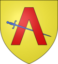
| A coat of arms is a special design that represents a family, a town, or an organization. Anguerny's coat of arms shows a golden background with a red V-shape, called a chevron. There's also a blue sword placed across the middle.
|
How Anguerny Was Governed
Anguerny was managed by a mayor and a local council. Here are some of the people who served as mayor:
| From | To | Name | Party |
|---|---|---|---|
| 1989 | 2001 | Paul Rivoalen | |
| 2001 | 2014 | Alain Yaouanc | Independent |
| 2014 | 2016 | Jean-Luc Guillouard |
Town Twinning: Friends Across Borders
Town twinning is when two towns in different countries form a special bond. They often visit each other and learn about different cultures. Anguerny has a twinning partnership with:
Anguerny's Population Over Time
The people who live in Anguerny are called Agernynois (for boys and men) or Agernynoises (for girls and women). Looking at population numbers helps us understand how the town has grown or changed over many years.
| Historical population | ||||||||||||||||||||||||||||||||||||||||||||||||||||||||||||||||||||||||||||||||||||||||||||||||||||||||||||||||
|---|---|---|---|---|---|---|---|---|---|---|---|---|---|---|---|---|---|---|---|---|---|---|---|---|---|---|---|---|---|---|---|---|---|---|---|---|---|---|---|---|---|---|---|---|---|---|---|---|---|---|---|---|---|---|---|---|---|---|---|---|---|---|---|---|---|---|---|---|---|---|---|---|---|---|---|---|---|---|---|---|---|---|---|---|---|---|---|---|---|---|---|---|---|---|---|---|---|---|---|---|---|---|---|---|---|---|---|---|---|---|---|---|
|
|
|||||||||||||||||||||||||||||||||||||||||||||||||||||||||||||||||||||||||||||||||||||||||||||||||||||||||||||||
| Source: EHESS and INSEE | ||||||||||||||||||||||||||||||||||||||||||||||||||||||||||||||||||||||||||||||||||||||||||||||||||||||||||||||||
Important Places and Buildings
- The Church of Saint Martin has a bell tower that dates back to the 11th century. This means it's over 900 years old! It's considered a historical monument, which means it's very important and protected. Inside the church, you can find four special items that are also protected as historical objects:
- A Tabernacle and Seating from the 19th century. A tabernacle is a special box where sacred items are kept.
- A painting called "Calvary" from the 17th century.
- A Retable from the 17th century. A retable is a decorative screen or panel behind an altar.
- The main Altar showing "The Crucifixion," made in 1760.
- A Tithe barn is a large barn where farmers used to store a portion of their crops as a tax.
- There are also 2 Festival halls where events and gatherings can be held.
- Saint Martin Church Picture Gallery
Fun Activities and Events
Every two years in the spring, Anguerny hosts an event called Romanes d'Anguerny. This is a local festival that brings the community together.
Images for kids
See also
 In Spanish: Anguerny para niños


