
Colonial Manor, New Jersey facts for kids
Quick facts for kids
Colonial Manor, New Jersey
|
|
|---|---|

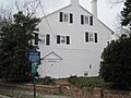
Ladd's Castle, listed on the NRHP
|
|

Colonial Manor, New Jersey
Location in Gloucester County, New Jersey

Colonial Manor, New Jersey
Location in New Jersey

Colonial Manor, New Jersey
Location in the United States
|
|
| Country | |
| State | |
| County | Gloucester |
| Township | West Deptford |
| Elevation | 377 ft (115 m) |
| Time zone | UTC−05:00 (Eastern (EST)) |
| • Summer (DST) | UTC−04:00 (EDT) |
| GNIS feature ID | 875572 |
Colonial Manor is a small community located in West Deptford Township, within Gloucester County, in the state of New Jersey, United States. It's known as an "unincorporated community," which means it's a neighborhood or area that doesn't have its own separate local government. Instead, it's part of the larger West Deptford Township.
| Top - 0-9 A B C D E F G H I J K L M N O P Q R S T U V W X Y Z |
Exploring Colonial Manor's Past
Colonial Manor has a rich history, with some very old buildings and important community groups. Let's take a look at what makes this place special.
Ladd's Castle: A Historic Home
One of the most famous landmarks in Colonial Manor is Ladd's Castle. It's also known as Candor Hall. This amazing building is the oldest brick house in all of Gloucester County.
Building a Landmark
Ladd's Castle was built around the year 1688. That's over 330 years ago! A man named John Ladd constructed it. He was a surveyor, which means he was an expert at measuring land.
A Surveyor's Legacy
It is believed that John Ladd even helped William Penn design the street layout for the city of Philadelphia. This shows how important his skills were back then. Ladd's Castle is so historically significant that it was added to the National Register of Historic Places in 1972. This list includes places across the country that are worth preserving because of their history.
Community Spirit: The Fire Department
The people of Colonial Manor have a strong sense of community. One great example of this is the Colonial Manor Volunteer Fire Department.
Serving the Community Since 1922
This important group was started in 1922. For over a century, brave volunteers have been protecting the community from fires and helping in emergencies. Volunteer fire departments are a big part of many small towns in the U.S., showing how neighbors help each other.
Images for kids
-
Ladd's Castle, a historic brick home in Colonial Manor.
