Columbia City, Indiana facts for kids
Quick facts for kids
Columbia City, Indiana
|
|||||
|---|---|---|---|---|---|
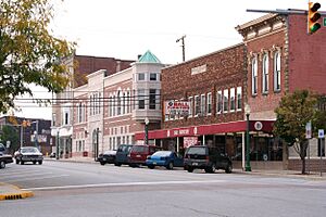
Downtown Columbia City
|
|||||
|
|||||
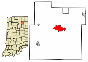
Location of Columbia City in Whitley County, Indiana.
|
|||||
| Country | United States | ||||
| State | Indiana | ||||
| County | Whitley | ||||
| Township | Columbia | ||||
| Government | |||||
| • Type | Mayor-council government | ||||
| Area | |||||
| • Total | 5.47 sq mi (14.17 km2) | ||||
| • Land | 5.45 sq mi (14.12 km2) | ||||
| • Water | 0.02 sq mi (0.05 km2) | ||||
| Elevation | 869 ft (265 m) | ||||
| Population
(2020)
|
|||||
| • Total | 9,892 | ||||
| • Density | 1,813.71/sq mi (700.34/km2) | ||||
| Time zone | UTC-5 (EST) | ||||
| • Summer (DST) | UTC-4 (EDT) | ||||
| ZIP code |
46725
|
||||
| Area code(s) | 260 | ||||
| FIPS code | 18-14716 | ||||
| GNIS feature ID | 2393606 | ||||
| Website | http://www.columbiacity.net | ||||
Columbia City is a city located in Columbia Township, Whitley County, Indiana, United States. In 2020, about 9,892 people lived there. This number was higher than in 2010, when 8,750 people lived in the city. Experts believe the population grew to about 10,064 people by 2023. Columbia City is the main city and the county seat of Whitley County. It is also part of the larger Fort Wayne area.
Contents
History of Columbia City
The first settlers who were not Native Americans arrived in the area in 1837. They came from New England after the Black Hawk War ended and the Erie Canal was finished. These early settlers were often called "Yankees" and were descendants of English Puritans who had settled in New England long ago.
Columbia City was started in 1839. At first, it was simply called "Columbia." However, in 1854, the name had to be changed because there was already another city named Columbia in Indiana. People held many discussions to pick a new name. Eventually, they chose "Columbia City" over "Beaver."
The city grew quickly after the Pittsburgh, Fort Wayne, & Chicago Railway was completed in 1856. Between 1865 and 1875, the number of people living in Columbia City tripled! The city officially became a part of Indiana in 1888.
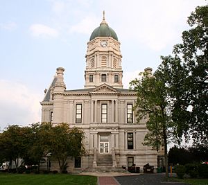
The Whitley County Courthouse was designed between 1888 and 1891 by Brentwood S. Tolan. This important building was added to the National Register of Historic Places in 1979. Other historic places in the city include the Thomas R. Marshall House, added in 1983, and the Columbia City Historic District, added in 1987.
Geography and Climate
According to the 2010 census, Columbia City covers about 5.601 square miles (14.51 square kilometers). Most of this area, about 5.58 square miles (14.45 square kilometers), is land. Only a small part, about 0.021 square miles (0.054 square kilometers), is water.
What is the Climate Like?
Columbia City has a climate known as a hot-summer humid continental climate. This means it has warm, humid summers and cold winters. The hottest temperature ever recorded in Columbia City was 103°F (39°C) on June 26, 1988. The coldest temperature ever recorded was -24°F (-31°C) between January 19 and 21, 1994.
| Climate data for Columbia City, Indiana, 1991–2020 normals, extremes 1963–present | |||||||||||||
|---|---|---|---|---|---|---|---|---|---|---|---|---|---|
| Month | Jan | Feb | Mar | Apr | May | Jun | Jul | Aug | Sep | Oct | Nov | Dec | Year |
| Record high °F (°C) | 66 (19) |
72 (22) |
84 (29) |
88 (31) |
94 (34) |
103 (39) |
101 (38) |
98 (37) |
96 (36) |
89 (32) |
77 (25) |
70 (21) |
103 (39) |
| Mean maximum °F (°C) | 53.9 (12.2) |
56.7 (13.7) |
69.6 (20.9) |
78.8 (26.0) |
86.0 (30.0) |
91.2 (32.9) |
91.6 (33.1) |
89.8 (32.1) |
88.2 (31.2) |
81.5 (27.5) |
66.9 (19.4) |
56.1 (13.4) |
93.3 (34.1) |
| Mean daily maximum °F (°C) | 31.7 (−0.2) |
35.4 (1.9) |
46.4 (8.0) |
59.4 (15.2) |
70.4 (21.3) |
79.3 (26.3) |
82.5 (28.1) |
80.7 (27.1) |
75.2 (24.0) |
62.7 (17.1) |
48.6 (9.2) |
36.7 (2.6) |
59.1 (15.0) |
| Daily mean °F (°C) | 24.0 (−4.4) |
27.0 (−2.8) |
36.9 (2.7) |
48.6 (9.2) |
59.8 (15.4) |
69.1 (20.6) |
72.3 (22.4) |
70.4 (21.3) |
63.8 (17.7) |
52.1 (11.2) |
39.9 (4.4) |
29.5 (−1.4) |
49.4 (9.7) |
| Mean daily minimum °F (°C) | 16.2 (−8.8) |
18.5 (−7.5) |
27.4 (−2.6) |
37.8 (3.2) |
49.2 (9.6) |
58.9 (14.9) |
62.1 (16.7) |
60.2 (15.7) |
52.5 (11.4) |
41.6 (5.3) |
31.2 (−0.4) |
22.3 (−5.4) |
39.8 (4.3) |
| Mean minimum °F (°C) | −6.6 (−21.4) |
−1.0 (−18.3) |
9.5 (−12.5) |
21.9 (−5.6) |
33.2 (0.7) |
44.8 (7.1) |
50.7 (10.4) |
48.3 (9.1) |
38.4 (3.6) |
27.0 (−2.8) |
15.5 (−9.2) |
2.9 (−16.2) |
−10.4 (−23.6) |
| Record low °F (°C) | −24 (−31) |
−17 (−27) |
−6 (−21) |
7 (−14) |
24 (−4) |
36 (2) |
39 (4) |
36 (2) |
27 (−3) |
17 (−8) |
0 (−18) |
−22 (−30) |
−24 (−31) |
| Average precipitation inches (mm) | 2.54 (65) |
1.95 (50) |
2.62 (67) |
3.81 (97) |
4.34 (110) |
4.62 (117) |
3.86 (98) |
4.07 (103) |
3.00 (76) |
2.85 (72) |
2.98 (76) |
2.43 (62) |
39.07 (993) |
| Average snowfall inches (cm) | 7.0 (18) |
6.5 (17) |
3.0 (7.6) |
0.3 (0.76) |
0.0 (0.0) |
0.0 (0.0) |
0.0 (0.0) |
0.0 (0.0) |
0.0 (0.0) |
0.0 (0.0) |
1.2 (3.0) |
3.4 (8.6) |
21.4 (54.96) |
| Average precipitation days (≥ 0.01 in) | 11.5 | 9.0 | 9.8 | 11.3 | 12.3 | 11.3 | 9.5 | 9.7 | 8.6 | 10.1 | 10.2 | 11.0 | 124.3 |
| Average snowy days (≥ 0.1 in) | 5.3 | 3.8 | 1.7 | 0.3 | 0.0 | 0.0 | 0.0 | 0.0 | 0.0 | 0.0 | 0.6 | 3.6 | 15.3 |
| Source 1: NOAA | |||||||||||||
| Source 2: National Weather Service | |||||||||||||
Economy and Jobs
About 12% of the people in Columbia City work in factories and manufacturing. This makes manufacturing a very important part of the city's economy. Currently, six businesses in the city employ between 50 and 350 people. These companies are:
- 80/20
- Coupled Products, LLC
- Alcoils, Inc.
- Reelcraft Industries, Inc.
- ChromaSource, Inc.
- Kilgore Manufacturing Company, Inc.
The city also has a strong history in farming, which helps its economy. Columbia City is located near other important cities like Fort Wayne (25 miles away), Warsaw (20 miles away), and South Bend (69 miles away). This makes it a good place for businesses.
Population and People
| Historical population | |||
|---|---|---|---|
| Census | Pop. | %± | |
| 1860 | 887 | — | |
| 1870 | 1,663 | 87.5% | |
| 1880 | 2,244 | 34.9% | |
| 1890 | 3,027 | 34.9% | |
| 1900 | 2,975 | −1.7% | |
| 1910 | 3,448 | 15.9% | |
| 1920 | 3,499 | 1.5% | |
| 1930 | 3,805 | 8.7% | |
| 1940 | 4,219 | 10.9% | |
| 1950 | 4,745 | 12.5% | |
| 1960 | 4,803 | 1.2% | |
| 1970 | 4,911 | 2.2% | |
| 1980 | 5,091 | 3.7% | |
| 1990 | 5,706 | 12.1% | |
| 2000 | 7,077 | 24.0% | |
| 2010 | 8,750 | 23.6% | |
| 2020 | 9,892 | 13.1% | |
| U.S. Decennial Census 2020 | |||
What the 2010 Census Showed
In 2010, there were 8,750 people living in Columbia City. These people lived in 3,658 households, and 2,235 of these were families. The city had about 1,568 people per square mile (605 people per square kilometer).
Most of the people in Columbia City were White (96.7%). A smaller number were African American (0.5%), Native American (0.3%), or Asian (0.5%). About 0.6% were from other backgrounds, and 1.4% were from two or more backgrounds. About 2.2% of the population was Hispanic or Latino.
Out of all the households:
- 30.9% had children under 18 living with them.
- 42.4% were married couples.
- 13.9% had a female head of household with no husband present.
- 4.8% had a male head of household with no wife present.
- 38.9% were not families.
About 33.5% of households had only one person living there. Also, 14.2% of households had someone aged 65 or older living alone. The average household had 2.32 people, and the average family had 2.93 people.
The average age of people in the city was 36.1 years.
- 24.9% of residents were under 18.
- 9.1% were between 18 and 24.
- 26.7% were between 25 and 44.
- 23.9% were between 45 and 64.
- 15.3% were 65 or older.
The city's population was 47.6% male and 52.4% female.
Healthcare
- Columbia City has a local branch of Parkview Health, which provides medical care.
Education
Columbia City has several schools for students of all ages:
- Columbia City High School
- Eagle Tech Academy
- Indian Springs Middle School
- Mary Raber Elementary School
- Little Turtle Elementary School
- Northern Heights Elementary School
- Coesse Elementary School
- Faith Christian Academy
The city also has a public library called the Peabody Public Library, where people can borrow books and other materials.
See also
 In Spanish: Columbia City (Indiana) para niños
 | Victor J. Glover |
 | Yvonne Cagle |
 | Jeanette Epps |
 | Bernard A. Harris Jr. |


