Condolden facts for kids
Condolden is a cool hill located in northern Cornwall, England, in the UK. Its highest point reaches 308 metres (about 1,010 feet) above sea level. Imagine standing on top of a 100-story building – that's how high it feels!
Condolden is about two miles (3 kilometers) southeast of the famous village of Tintagel. It sits right on the edge of the Tintagel civil parish, with Waterpit Down to its east and Penpethy to its west. This makes Condolden the highest spot in the entire Tintagel area.
Contents
Discovering Condolden Hill
Condolden Hill is more than just a high point; it's a place with a long history.
Ancient History: Bronze Age Burials
One of the most interesting things about Condolden is a large Bronze Age burial mound, called a barrow. This barrow is the biggest one in the Tintagel area. People from the Bronze Age (which was thousands of years ago!) built these mounds to bury important people. This particular barrow hasn't been dug up by archaeologists yet, so we don't know all its secrets!
Iron Age Forts and Farming
Near Condolden, there was once an Iron Age fort called Trenale Bury. Sadly, this ancient fort was plowed away during the Second World War to make more space for farming. Today, the land around Condolden is mostly used for growing crops.
What is a Trig Point?
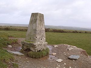
On top of the Bronze Age barrow, you'll find an Ordnance Survey triangulation point. A "trig point" is a special marker used by mapmakers to help them create accurate maps of the land. They use these points to measure distances and angles very precisely.
Nearby Places
Around the edges of Condolden Hill, you'll find several small places. These include Halgabron, Trenale, Downrow, Truas, Menadue, and Trewarmett. Each of these places adds to the local charm of the area around Condolden.
 | Dorothy Vaughan |
 | Charles Henry Turner |
 | Hildrus Poindexter |
 | Henry Cecil McBay |


