Conguillío National Park facts for kids
Quick facts for kids Parque Nacional Conguillío |
|
|---|---|
|
IUCN Category II (National Park)
|
|
|
|
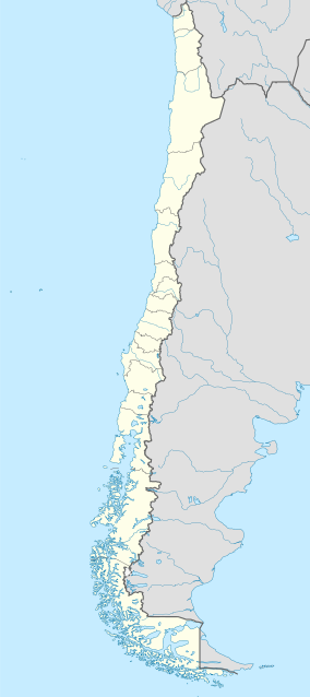
| Location | La Araucanía Region, Chile |
| Nearest city | Melipeuco, Curacautín |
| Area | 608 km2 (150,000 acres) |
| Established | 1950 |
| Visitors | 21,805 (in 2004) |
| Governing body | Corporación Nacional Forestal |
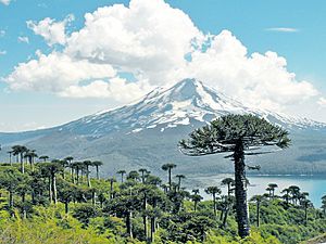
Conguillío National Park is a beautiful natural park in the Andes mountains of Chile. It is located in the Araucanía Region, also known as Region IX. The park's name comes from the Mapuche language. It means "water with Araucaria seeds."
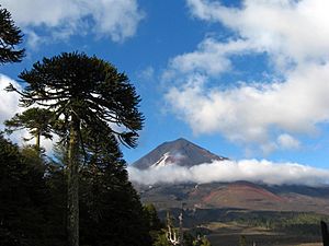
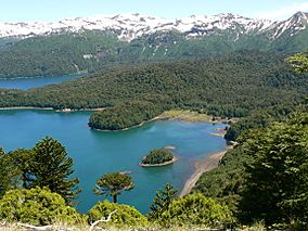
This park is famous for its amazing landscapes. You can see the Llaima volcano and Sierra Nevada mountain. There are also areas of green plants surrounded by old lava flows. The park is a very wet and humid place.
You will find huge forests here, mostly made of Araucaria trees and Nothofagus trees. Many small lakes add to the park's beauty. People sometimes call the park Los Paraguas, which means "The Umbrellas." This is because the Monkey Puzzle trees (Araucarias) look like umbrellas.
The park was even used as a place to film Walking with Dinosaurs. This was a popular TV show made by the BBC.
Contents
Park History
Conguillío National Park was officially created in 1950. In 1983, UNESCO named it a Biosphere Reserve. This means it is a special place where nature is protected. This reserve is known as the Araucarias Biosphere Reserve.
The park is also part of the larger Kütralkura Geopark. This Geopark was recognized by UNESCO in 2019. Geoparks are areas with important geological features.
Getting to the Park
The park is about 120 kilometers (75 miles) east of Temuco. There are a few ways to enter the park.
Accessing Los Paraguas Sector
You can reach this part of the park from towns like Cajón and Cherquenco. The road is paved in some parts and gravel in others. During winter, you might need special chains for your tires. You may also need a four-wheel-drive vehicle.
Accessing Conguillío Sector
This area can be reached from Chile Route 181. This route is paved from Victoria to Curacautín. From Curacautín, the road to the park is paved for the first 10 kilometers (6 miles). The rest is gravel. This road is usually open all year up to the Captrén Hut. Further parts are only open in summer, from November to March.
Accessing Melipeuco Sector
This is the main entrance to the park. You can get here from Temuco, passing through Cunco and Melipeuco. The road is paved until the Truful-Truful river. After that, it is a gravel road. This route is open all year to the park.
Rivers and Water Fun
The Lonquimay River flows into the Biobío river. The Truful Truful river is a great spot for fishing. It flows over volcanic rock and into Conguillío Lake. About 14 kilometers (9 miles) from Melipeuco, you can find the Saltos del Truful Truful waterfalls. Rainbow trout are common in this river. You can go swimming, rowing, and fishing in the park's waters. Motorized boats are also allowed.
Sierra Nevada Volcano
The Sierra Nevada volcano has five amazing lookout points. The hike to these points takes about five to six hours. But the effort is worth it! From the top, you get incredible views. You might even see condors flying high above.
Llaima Volcano
Llaima is one of the most active volcanoes in Chile. It has a long history of powerful eruptions.
Llaima Volcano Eruption in 2008
The Llaima volcano last erupted on January 1, 2008. The park had to be quickly cleared. About 150 tourists and park staff were safely evacuated. The volcano erupted around 6:20 PM local time. During the eruption, the volcano shot out ash and rocks. These materials went thousands of feet above the main crater.
Hiking Trails
There are many great trails for hiking in the park. Some popular ones include Sierra Nevada, Los Carpinteros, Las Araucarias, Las Vertientes, and Cañón de Truful-Truful.
If you enter the park near Captrén lagoon, there is a path that goes all around the lagoon. It is about 2 kilometers (1.24 miles) long. This walk is easy and good for everyone. You can fish in Captrén lagoon, but swimming and boating are not allowed. This is because the lagoon is a special place for birds.
Another trail is called the Carpenters' footpath. It is about 5 kilometers (3.11 miles) long. This trail goes through forests of Araucaria, coigüe, and lenga trees. It ends at Laguna Captrén. On this path, you will see the "Araucaria Mother." This is a huge Araucaria tree with a trunk that is 2 meters (6.56 feet) wide!
Plants of the Park
You will find many types of trees in the park. These include Coigües, robles, and raulíes. Other trees like lengas, ñirres, avellanos, maitenes, cipreses de la cordillera, and lleuques grow in certain areas.
Animals of the Park
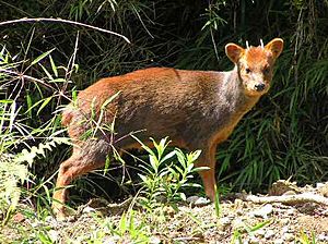
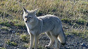
The park is home to many interesting animals. You might spot mammals like pumas, culpeos (Andean foxes), chillas (gray foxes), and the kodkod (a small wild cat). There are also many different kinds of birds. These include ducks, condors, eagles, and wood pigeons.
Park Administration
The main office for the park's administration is located near Conguillío Lake. This is where the CONAF (National Forest Corporation) staff work.
Best Time to Visit
The best time to visit Conguillío National Park is during spring and summer. This is from November to March. The weather is milder then, and the roads are usually in great condition.
During winter, the park is perfect for visiting the Araucarias ski center. This ski center is on the west side of the Llaima volcano. It has ski lifts, a cafeteria, a ski school, and places to rent equipment. You can also find lodging in a refuge there.
|
See also
 In Spanish: Parque nacional Conguillío para niños
 | William L. Dawson |
 | W. E. B. Du Bois |
 | Harry Belafonte |


