Coode Island facts for kids
Quick facts for kids Coode IslandVictoria |
|
|---|---|

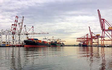
Container docks along the eastern side of the island
|
|
| Elevation | 5 m (16 ft) |
| Area | 0.97 km2 (0.4 sq mi) |
| Region | West Melbourne |
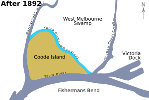
Coode Island used to be an island near where the Yarra and Maribyrnong Rivers meet. It's about 4 kilometers west of central Melbourne, Australia. The island was created in 1887 when the Coode Canal was dug. Later, in the 1930s, it became connected to the mainland.
Today, this low-lying area is part of the Port of Melbourne. It is home to Swanson and Appleton Docks. These docks are used for storing shipping containers and have train yards. There are also several places for storing chemicals on the site.
Contents
History of Coode Island

Before the 1880s, the area that became Coode Island was a large, flat wetland. The island was formed after the Coode Canal was dug in 1886. This canal was made to shorten the Yarra River. A new shipping canal was built south of the river's old path. This allowed ships to reach Yarraville from the Port of Melbourne.
The new island was surrounded by the canal to the south. The Maribyrnong River was to its west. The Yarra River was to its north and east. Once it was formed, the island became an industrial area. It covered about 97 hectares (240 acres).
Naming the Island
The island was named after Sir John Coode. He was an English engineer who designed harbors. The Melbourne Harbor Trust hired him to choose the best path for the canal. This was part of developing the Port of Melbourne.
Over many years, the old path of the Yarra River was filled in. The nearby swamps were also filled. By the mid-1900s, Coode Island was no longer a true island. However, the name stuck.
Early Uses of the Land
By 1909, the area was used as an animal quarantine station. This meant animals were kept there to stop diseases from spreading. After 1915, it became a special hospital for people with serious illnesses.
In the 1920s, some people lived there in simple huts or old ships. In 1927, the Larkin Aircraft Supply Company started working on the island. They built a factory and an airfield there. This airfield was used until World War II.
Modern Development
In 1960, the area began to be used for storing chemicals like petrochemicals. In 1968, the Swanson Dock container terminal was built. This dock is on the south side of the former island. Its construction made Coode Island smaller.
The 1991 Incident
On August 21, 1991, a fire started at a chemical storage facility on Coode Island. About 8.5 million liters of chemicals burned. These included substances like acrylonitrile and benzene. The fire created a cloud of smoke over nearby suburbs. Strong winds helped to spread this cloud.
The fire spread between tanks because they shared a common vent system. When the tanks were designed, a safety system called nitrogen blanketing was not included. The common vent system was added later to collect fumes for environmental reasons.
After the fire, there were ideas to move the chemical facility. One idea was to move it to Point Lillias near Geelong. However, concerns about the environment and Aboriginal heritage stopped these plans.
In 2000, the Bracks Government announced a decision. Coode Island would remain Victoria's main place for storing petrochemicals. Six companies now lease the facility from the Melbourne Port Authority.
 | William M. Jackson |
 | Juan E. Gilbert |
 | Neil deGrasse Tyson |


