Copper Hill, Arizona facts for kids
Quick facts for kids
Copper Hill, Arizona
|
|
|---|---|

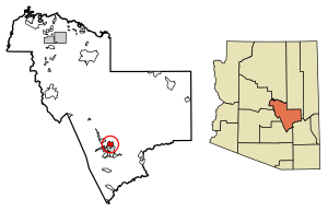
Location of Copper Hill in Gila County, Arizona.
|
|
| Country | United States |
| State | Arizona |
| County | Gila |
| Area | |
| • Total | 7.36 sq mi (19.05 km2) |
| • Land | 7.35 sq mi (19.05 km2) |
| • Water | 0.00 sq mi (0.00 km2) |
| Elevation | 4,127 ft (1,258 m) |
| Population
(2020)
|
|
| • Total | 158 |
| • Density | 21.48/sq mi (8.30/km2) |
| Time zone | UTC-7 (Mountain (MST)) |
| ZIP code |
85501
|
| Area code(s) | 928 |
| GNIS feature ID | 42763 |
Copper Hill is a small community in Gila County, Arizona, United States. It is called a census-designated place (CDP). This means it's an area that looks like a town but isn't officially set up as one.
Copper Hill is located near US Route 60. This is a major road in the area. It sits northeast of the city of Globe. In 2010, about 108 people lived there. By 2020, the population grew to 158 people.
Where is Copper Hill Located?
Copper Hill is found at specific coordinates: 33.433316 degrees North and 110.748494 degrees West. These numbers help pinpoint its exact spot on a map.
The community covers an area of about 7.35 square miles (19.05 square kilometers). Almost all of this area is land. There is very little water, only about 0.001 square miles.
How Many People Live Here?
The number of people living in Copper Hill has changed over time.
- In 2010, the population was 108 people.
- By 2020, the population had grown to 158 people.
This information comes from the official U.S. Decennial Census. The census counts everyone in the country every ten years.
See also
 In Spanish: Copper Hill (Arizona) para niños
 | Kyle Baker |
 | Joseph Yoakum |
 | Laura Wheeler Waring |
 | Henry Ossawa Tanner |


