
Coquet Stop Line facts for kids
The Coquet Stop Line was a series of defenses built during World War II in Northumberland, England. It stretched from Amble along the River Coquet. Its main goal was to stop a possible invasion by German forces. It was designed to slow down any German army coming from the north. This would give the British army time to get ready further south, on the Tyne Stop Line.
The Coquet Stop Line was mostly made of strong concrete buildings called pillboxes. These pillboxes had a special "Lozenge" shape, which looks a bit like a diamond. This shape is mostly found in the North East of England and parts of Yorkshire. These pillboxes were often built with open land, like a river or a flat area, in front of them. This allowed soldiers inside to see far and shoot at enemies. Behind the pillbox, where the entrance was, there was often cover to protect soldiers if they needed to retreat.
A few of these pillboxes are now gone. For example, one near Felton village and another near the A1 road at West Moor have disappeared. You can still see the remains of a sandbag pillbox near Amble Harbour. It sits across from a large concrete block that was part of a harbour chain, used to block the harbor entrance. There's also a brick "lozenge" shaped building near the football field in Warkworth. However, this one was likely part of the "Coastal Crust," which was a different defense line right on the coast.
Contents
Other Defenses in the Area
There are other pillboxes along the River Coquet that were probably not part of the main Coquet Stop Line.
Sandbag Pillbox at Thropton
One unique sandbag pillbox, shaped like a "beehive," is in a garden behind the Cross Keys pub in Thropton. It was built to protect the road bridge over the Wreigh Burn. The 250th Field Company of Royal Engineers built many sandbag pillboxes in this area between July and September 1940. However, local companies were hired to build the concrete pillboxes.
Pillbox Near Morwick
Another pillbox is located near Morwick, close to the main railway line on the east coast. This pillbox is rectangular and made of both brick and concrete. It was likely built to protect the railway bridge (viaduct) or the soldiers who would have been ordered to blow up the viaduct if an invasion happened. The viaduct needed to stay open as long as possible to move trains and supplies.
Gloster Hill Cottage Pillbox
A very unusual pillbox can be found by the road between Amble and Warkworth at Gloster Hill. This pillbox looks like an old stone cottage from the front. It has a stone and concrete front, but the rest of it is made from sandbags. There's a similar one at Hemscott Hill, Cresswell.
Pillboxes Out of Sequence
Some pillboxes, like those at Brainshaugh and West Thirston, might not be part of the Coquet Stop Line. Their identification numbers don't match the others in the line. They might have been part of a different defense line that ran from north to south further inland. Pillboxes at Hazon, Brainshaugh, Morwick, West Thirston, Earsdon, Longhirst, Bothal Barns, and East Moor (and possibly Eshott) form a line where the pillboxes are about two miles apart.
Rothbury's Hidden Pillbox
There's another modified "lozenge" pillbox in Rothbury. It's a standard "lozenge" type, but its entrance and porch are on the left side instead of the back. This pillbox is well hidden on the south side of the river, almost opposite the Whitton road bridge. It was placed there to defend the bridge. The three openings (embrasure) at the front are just above ground level. The left and right openings have been made narrower, like a letterbox. This pillbox doesn't have an identification number, so it might not be part of the main stop line.
Where to Find the Pillboxes
The pillboxes listed below have been confirmed as part of the Coquet Stop Line. They are listed from east to west. Remember, most of these sites are on private land, so you should not try to visit them without permission.
| ID | Location | Grid reference | Notes |
|---|---|---|---|
| P454 | West Thirston | NZ19009990 | |
| P305 | Catheugh Plantation | NZ14909950 | |
| P306 | Weldon Bridge | NZ13919833 | |
| P307 | Brinkheugh | NZ12509830 | |
| P308 | Middleheugh, Brinkburn Priory | NZ11459850 | |
| P309 | Pauperhaugh | NZ09859945 | |
| P310 | Brinkburn Station | NZ08759960 | |
| P311 | Rothbury school area | Removed | |
| P312 | Cartington near Rothbury | NU06760041 | On Garleigh Moor |
| P313 | Carterside near Rothbury | NU04560100 | |
| P314 | Newtown | NU03560105 | |
| P315 | Ryehill | NU02150159 | |
| P318 | Little Tosson | NU00860140 | |
| P319 | Bickerton | NU00080066 | |
| P320 | Bickerton | NT99320042 | |
| P321 | Hepple | NY98489979 | Has sunk a lot due to the river |
| P322 | Hepple | NT97770002 | |
| P323 | Harehaugh | NT97249996 | |
| P--- | Brainshaugh (north of the river) | NU20400340 | |
| P583 | Morwick | NU23300330 | |
| P--- | Rothbury | NU05600160 |
Images for kids
-
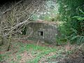
Pillbox P305 Catheugh Plantation, hidden by trees.
-
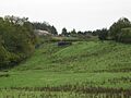
Pillbox P306 Weldon Bridge, seen from the old A697 road.
-
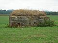
Pillbox P319 Bickerton, seen from a small road.
-
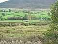
Pillbox P320 Bickerton, seen across the River Coquet.
-
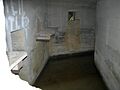
Inside a well-preserved pillbox on the Coquet Stop Line. A historical message was written above the doorway.


See also
