Coromandel, New Zealand facts for kids
Quick facts for kids
Coromandel
Kapanga (Māori)
|
|
|---|---|

Coromandel town
|
|
| Country | New Zealand |
| Region | Waikato |
| District | Thames-Coromandel District |
| Ward | Coromandel-Colville ward |
| Community Board | Coromandel-Colville Community |
| Electorates |
|
| Area | |
| • Total | 10.89 km2 (4.20 sq mi) |
| Population
(June 2023)
|
|
| • Total | 1,930 |
| • Density | 177.2/km2 (459.0/sq mi) |
| Postcode(s) |
3506
|
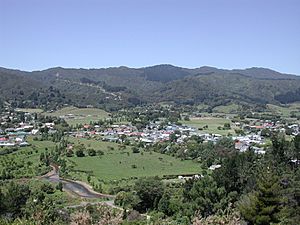
Coromandel, also known as Coromandel Town, is a small town in New Zealand. Its Māori name is Kapanga. It is located on the western side of the Coromandel Peninsula, right on the Coromandel Harbour. This area is part of the North Island.
Coromandel Town is about 75 kilometres east of Auckland. However, the road journey is much longer, around 190 km. This is because the road winds along the coast. In 2018, about 1,743 people lived here.
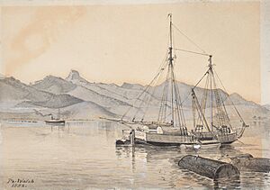
The town got its name from a ship called HMS Coromandel. This ship sailed into the harbour in 1820. Long ago, Coromandel Harbour was a very busy port. It helped support the area's gold mining and kauri tree industries. Today, the main jobs in Coromandel are in tourism and mussel farming.
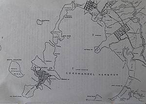
Coromandel Harbour is a wide bay on the Hauraki Gulf. Several islands protect it, with Whanganui Island being the largest. The town and its surroundings are a popular spot for New Zealanders to spend their summer holidays. Coromandel Town is known for its artists and crafts. Many people here enjoy an alternative lifestyle. It is also famous for mussel farming and fishing. A popular tourist spot is the Driving Creek Railway.
Contents
Coromandel's Past: A Town's Beginning
The government first planned for Coromandel Town to be built on Whanganui Island. Maps were drawn, and land was sold. But this plan did not work out very well. The land on the island was too steep. Also, there was no good source of fresh water. Most of the land plots were left empty. The government then bought them back. That is why the town was built where it stands today.
Who Lives in Coromandel?
Coromandel covers about 10.89 square kilometres. In 2023, it had an estimated population of about 1,900 people. This means there are around 174 people living per square kilometre.
In 2018, Coromandel had 1,743 residents. This was a good increase from previous years. There were 720 households in the town. The population included slightly more females than males. The average age of people in Coromandel was 52.5 years. This is older than the national average for New Zealand. About 14.8% of the people were under 15 years old. Around 29.3% were 65 or older.
Most people in Coromandel are of European background (83.1%). A significant number are Māori (29.9%). Some people also identify with Pacific peoples or Asian backgrounds. People can choose more than one ethnicity. About 16% of the residents were born outside New Zealand.
When asked about religion, most people (59.2%) said they had no religion. About 26% were Christian. Some followed Māori religious beliefs or other religions.
Learning in Coromandel
Coromandel has a school called Coromandel Area School (Te Kura a Rohe o Waiau). It is a school for all ages, from year 1 to year 13. This means it teaches students from around 5 years old up to 18 years old. The school first opened in 1875.
There used to be another school, Coromandel Rudolf Steiner School. It was a private school for younger children. However, it closed at the end of 2007.
Marae: Important Meeting Places
The Manaia Marae and Te Kou o Rehua meeting house are important places in Coromandel. A marae is a special meeting ground for Māori people. This marae is used by the Ngāti Pūkenga iwi (tribe). It is also used by their Ngāti Maru hapū (sub-tribe).
In 2020, the government provided money to improve the marae. This project also helped create jobs for local people.
The Old Coromandel Hospital building is another meeting place. It is used by the Te Patukirikiri iwi.
{{Wide image|CoromandelPanorama.JPG|800px|A wide view of Coromandel Town from a lookout point in the Kauri Block.]]
Coromandel's Weather
Coromandel has a mild climate. Here's a look at the average temperatures and rainfall:
| Climate data for Coromandel (1981–2010) | |||||||||||||
|---|---|---|---|---|---|---|---|---|---|---|---|---|---|
| Month | Jan | Feb | Mar | Apr | May | Jun | Jul | Aug | Sep | Oct | Nov | Dec | Year |
| Mean daily maximum °C (°F) | 23.7 (74.7) |
23.9 (75.0) |
22.6 (72.7) |
20.2 (68.4) |
17.7 (63.9) |
15.5 (59.9) |
14.7 (58.5) |
15.2 (59.4) |
16.7 (62.1) |
18.1 (64.6) |
20.0 (68.0) |
22.1 (71.8) |
19.2 (66.6) |
| Daily mean °C (°F) | 19.2 (66.6) |
19.6 (67.3) |
18.1 (64.6) |
15.9 (60.6) |
13.7 (56.7) |
11.6 (52.9) |
10.7 (51.3) |
11.2 (52.2) |
12.6 (54.7) |
14.1 (57.4) |
15.8 (60.4) |
17.8 (64.0) |
15.0 (59.1) |
| Mean daily minimum °C (°F) | 14.7 (58.5) |
15.3 (59.5) |
13.6 (56.5) |
11.6 (52.9) |
9.8 (49.6) |
7.7 (45.9) |
6.6 (43.9) |
7.3 (45.1) |
8.6 (47.5) |
10.1 (50.2) |
11.6 (52.9) |
13.5 (56.3) |
10.9 (51.6) |
| Average rainfall mm (inches) | 112.8 (4.44) |
155.9 (6.14) |
156.2 (6.15) |
184.1 (7.25) |
138.1 (5.44) |
192.4 (7.57) |
215.3 (8.48) |
212.0 (8.35) |
186.0 (7.32) |
142.6 (5.61) |
146.6 (5.77) |
150.5 (5.93) |
1,992.5 (78.45) |
| Source: NIWA | |||||||||||||
 | Victor J. Glover |
 | Yvonne Cagle |
 | Jeanette Epps |
 | Bernard A. Harris Jr. |


