Coulombe River facts for kids
Quick facts for kids Colombe River |
|
|---|---|

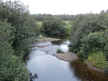
Coulombe River upstream of Center Road in Beaulac-Garthby.
|
|
| Country | Canada |
| Province | Quebec |
| Region | Estrie |
| MRC | Le Haut-Saint-François Regional County Municipality |
| Municipality | Saints-Martyrs-Canadiens and Weedon |
| Physical characteristics | |
| Main source | Marsh area Saints-Martyrs-Canadiens 367 m (1,204 ft) 45°51′48″N 71°31′43″W / 45.86333°N 71.528536°W |
| River mouth | Lake Louise (Estrie), Saint-François River Beaulac-Garthby 248 m (814 ft) 45°49′32″N 71°23′43″E / 45.82555°N 71.39528°E |
| Length | 138 km (86 mi) |
| Basin features | |
| Progression | Saint-François River, St. Lawrence River |
| Tributaries |
|
The Coulombe River is a river in Quebec, Canada. It flows into Lake Aylmer, which is part of the Saint-François River system. The Saint-François River eventually joins the mighty St. Lawrence River.
The Coulombe River flows through two main areas in Quebec:
- Saints-Martyrs-Canadiens, located in the Centre-du-Québec region.
- Beaulac-Garthby, found in the Estrie region.
Contents
Where Does the Coulombe River Flow?
The Coulombe River is surrounded by other important water areas. These are called watersheds.
- To the north: Lake Breeches and Sunday Lake.
- To the east: Moose River, Longue Pointe watercourse, Lake Aylmer, and the Saint-François River.
- To the south: Lake Aylmer and Ward Bay.
- To the west: Rivière au Canard (Haut Saint-François).
The River's Beginning
The Coulombe River starts in a marshy area. This spot is about 2 kilometers (1.2 miles) west of Mont Louise. It's also 1.6 kilometers (1 mile) south of the village of Saints-Martyrs-Canadiens.
The River's Journey
From its starting point, the Coulombe River flows for about 13.8 kilometers (8.6 miles). It travels through several sections:
- It flows eastward for 3.1 kilometers (1.9 miles). This section ends where it meets the stream from Lac Rond.
- It continues eastward for 2.6 kilometers (1.6 miles) to the north shore of Lac Coulombe.
- The river then crosses Lac Coulombe for 0.8 kilometers (0.5 miles). Lac Coulombe is 1.4 kilometers (0.9 miles) long and sits at an altitude of 301 meters (988 feet).
- Next, it flows east for 0.8 kilometers (0.5 miles). Here, it crosses Route 161.
- It travels eastward for 2.8 kilometers (1.7 miles). This is where the Coulombe North River, its main branch, joins it.
- The river then flows southeast for 2.2 kilometers (1.4 miles) to a country road.
- Finally, it continues southeast for 1.5 kilometers (0.9 miles) until it reaches its end.
Where the River Ends
The Coulombe River empties into Ward Bay, which is part of Lake Aylmer. This spot is about 1.3 kilometers (0.8 miles) southwest of the village of Beaulac-Garthby. The area around Ward Bay is a popular spot for vacations and resorts.
What's in a Name?
The name "Rivière Coulombe" was officially recorded on December 5, 1968. This was done by the Commission de toponymie du Québec, which is like the official naming board for places in Quebec.
 | Delilah Pierce |
 | Gordon Parks |
 | Augusta Savage |
 | Charles Ethan Porter |

