
Courland Governorate facts for kids


The Courland Governorate was a large area, like a province, that belonged to the Russian Empire. It was formed in 1795. This happened during a time called the Third Partition, when the lands of the Duchy of Courland and Semigallia became part of Russia.
Where was Courland Governorate?
This region was located in a part of Europe near the Baltic Sea. To its north, you would find the Gulf of Riga, the Baltic Sea, and another Russian province called the Governorate of Livonia. The Baltic Sea was also to its west.
To the south, it bordered the Vilna Governorate and Prussia. To the east, it was next to the Vitbesk Governorate and the Minsk Governorate.
How did Courland Governorate end?
The Courland Governorate existed until 1915. In that year, the German Empire took control of it during World War I.
Russia officially gave up the governorate later. This happened during the Treaty of Brest-Litovsk on March 3, 1918.
Images for kids
-
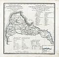
German and Russian map of the Courland Governorate

See also
 In Spanish: Gobernación de Curlandia para niños
