
Coyote Gulch facts for kids

Coyote Gulch is a long, winding canyon in southern Utah, in the western United States. It's like a giant natural playground! This amazing place is over 25 miles (40 km) long. It has many cool rock formations. You can see tall canyon walls, narrow slot canyons, and even natural arches and bridges.
Coyote Gulch is a small river that flows into the Escalante River. It starts high up on the Straight Cliffs Formation. This area is part of the Kaiparowits Plateau. Many small streams come together to form Coyote Gulch. These streams include Dry Fork, Big Hollow, and Hurricane Wash. Over time, the water has carved a deep canyon. Some parts are up to 900 feet (274 m) deep!
The upper parts of Coyote Gulch are in the Grand Staircase–Escalante National Monument. The lower parts are in the Glen Canyon National Recreation Area. Both are protected areas.
Contents
How to Visit Coyote Gulch

You can get into the main canyon of Coyote Gulch from different trails. These trails are along the Hole-in-the-Rock Road (HITRR). This road is unpaved. It goes into the Grand Staircase-Escalante National Monument. You can find it about 5 miles (8 km) east of Escalante, Utah.
- Red Well Trailhead: This trail leads into the main canyon. It's near where Big Hollow Wash joins the main channel.
- Hurricane Wash Trail: This trail starts right off the HITRR.
- Fortymile Ridge Road: This road has a trailhead that leads to the middle of Coyote Gulch. It's a bit of a steep climb over smooth rock.
- Crack-in-the-Wall Route: At the end of Fortymile Ridge Road, you can find a trail to the end of Coyote Gulch. This path is tricky! You have to squeeze through a narrow crack in the canyon rim. Then, you slide down a 600-foot (183 m) tall sand dune. It's an adventure!
Amazing Features of the Canyon
Walking through Coyote Gulch is like exploring a natural wonderland. The streambed is usually only a few inches deep. You can wade through it, surrounded by trees and plants.
- Jacob Hamblin Arch: In the middle of the canyon, you'll find Jacob Hamblin Arch. It's also called Lobo Arch. This arch is huge! You can even walk under an overhang on the other side of the canyon.
- Coyote Natural Bridge: Further downstream, there's Coyote Natural Bridge. It's a smaller hole carved into a large sandstone fin.
- Cliff Arch: Even further down, you'll see Cliff Arch. It looks like a "jug-handle" shape in the north wall of the canyon.
- Stevens Arch: Just outside the canyon's mouth, high above the Escalante River, is Stevens Arch. Its opening is about 220 feet (67 m) wide!
You'll also find many small waterfalls and cascades in the canyon. Some are easy to climb over. Others are a bit harder, and you might need to walk around them.
Exploring Dry Fork Slot Canyons
The northern part of Coyote Gulch is called the Dry Fork. It's a very popular spot! A short road leads to a trailhead above the wash. After a quick walk down to the canyon floor, you'll find several amazing slot canyons.
The Dry Fork is a great example of how water can carve rock. Over a long time, occasional flash floods have made narrow grooves in the Navajo Sandstone. The Dry Fork slot canyon is about 20 feet (6 m) deep. You can follow it upstream for hundreds of yards.
- Peekaboo Gulch: Just downstream from the Dry Fork, Peekaboo Gulch is even narrower. It's like a tube that empties into the dry streambed.
- Spooky Gulch: Further downstream, Spooky Gulch is over 30 feet (9 m) deep. But it's super narrow! It's usually less than 15 inches (38 cm) wide. You might have to take off your backpack and walk sideways to get through!
- Brimstone Gulch: This is the last named slot canyon in the Dry Fork area. It's even narrower than Spooky Gulch. Eventually, it becomes too narrow for anyone to pass through.
Images for kids
-
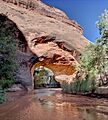
Coyote Natural Bridge is a natural wonder.
-
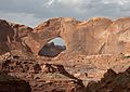
Stevens Arch is a huge natural arch.
-
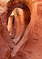
Peek-a-Boo Gulch is a very narrow slot canyon.


