Crane, Indiana facts for kids
Quick facts for kids
Crane, Indiana
|
|
|---|---|

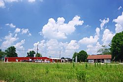
Crane NSA Visitor Center (right) and the Lonely Night Saloon (left)
|
|

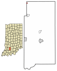
Location in Martin County, Indiana
|
|
| Country | United States |
| State | Indiana |
| County | Martin |
| Township | Perry |
| Area | |
| • Total | 0.12 sq mi (0.31 km2) |
| • Land | 0.12 sq mi (0.31 km2) |
| • Water | 0.00 sq mi (0.00 km2) |
| Elevation | 597 ft (182 m) |
| Population
(2020)
|
|
| • Total | 166 |
| • Density | 1,383.33/sq mi (532.46/km2) |
| Time zone | UTC-5 (Eastern (EST)) |
| • Summer (DST) | UTC-5 (EST) |
| ZIP code |
47522
|
| Area code(s) | 812 and 930 |
| FIPS code | 18-15652 |
| GNIS feature ID | 2396667 |
Crane is a small town in Perry Township, Martin County, in the U.S. state of Indiana. In 2020, the town had a population of 166 people. Crane is located right next to the Naval Surface Warfare Center Crane Division, a large naval base.
Contents
History of Crane
The town of Crane was first established in 1940. It was originally known by a different name: "Burns City Ammunition Depot."
In 1943, the community was renamed "Crane." This new name honored William M. Crane, who was the first chief of the Navy Bureau of Ordnance.
Geography of Crane
Crane is situated in the northwest part of Martin County. Its western edge is right along the border of Daviess County.
The Naval Surface Warfare Center Crane Division is located to the east of the town. A visitor center for the base is actually inside Crane. Indiana State Road 558 runs through the southern part of Crane. This road connects the town to U.S. Route 231 to the west. Also, Interstate 69 passes just north of Crane.
According to the U.S. Census Bureau, Crane covers a total area of about 0.12 square miles (0.31 square kilometers). All of this area is land. A small stream called Culpepper Branch starts in Crane. It flows southeast to First Creek, which then turns west to join the White River near Newberry.
Population and People
| Historical population | |||
|---|---|---|---|
| Census | Pop. | %± | |
| 1970 | 339 | — | |
| 1980 | 297 | −12.4% | |
| 1990 | 216 | −27.3% | |
| 2000 | 203 | −6.0% | |
| 2010 | 184 | −9.4% | |
| 2020 | 166 | −9.8% | |
| U.S. Decennial Census | |||
The population of Crane has changed over the years. In 1970, there were 339 people living here. By 2020, the population was 166.
2010 Census Information
In 2010, there were 184 people living in Crane. These people lived in 80 different homes. The town had about 109 housing units in total.
The average number of people in each home was 2.30. The median age of residents in Crane was 39.4 years old. About 26.1% of the residents were under 18 years old.
Nearby Highways
Several important roads are close to Crane:
 SR 558
 US 231, about 0.5 miles (0.8 km) west
 SR 45, about 0.5 miles (0.8 km) west
 I-69, about 2 miles (3.2 km) north
 SR 58, about 2 miles (3.2 km) north
See also
 In Spanish: Crane (Indiana) para niños

