Cristianitos Creek facts for kids
Quick facts for kids Cristianitos Creek |
|
|---|---|

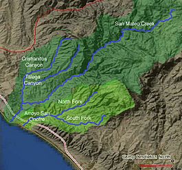
Map of San Mateo Creek and Arroyo San Onofre drainage basins. San Mateo Creek basin is in dark green.
|
|
| Country | United States |
| State | California |
| Region | Orange County, San Diego County |
| Physical characteristics | |
| Main source | at the head of Cristianitos Canyon, Santa Ana Mountains, in Orange County County 800 ft (240 m) 33°30′36″N 117°33′3″W / 33.51000°N 117.55083°W |
| River mouth | confluence with San Mateo Creek, in San Diego County 75 ft (23 m) 33°25′11″N 117°34′13″W / 33.41972°N 117.57028°W |
| Length | 7 mi (11 km) |
| Basin features | |
| Tributaries |
|
Cristianitos Canyon Creek is a small stream, also known as an arroyo, located in Southern California. It's a branch, or tributary, of the larger San Mateo Creek. This creek starts high up in the Santa Ana Mountains in Orange County. It flows for about 7 miles, ending in San Diego County where it joins San Mateo Creek.
Contents
Where Does Cristianitos Creek Flow?
The creek begins at the top of Cristianitos Canyon. This is in the foothills of the Santa Ana Mountains, in Orange County. The starting point is about 800 feet (244 meters) above sea level.
From there, Cristianitos Creek flows southwest through Cristianitos Canyon. It then turns south. Finally, it meets San Mateo Creek at an elevation of about 75 feet (23 meters) above sea level. This meeting point is in San Diego County.
What Are Tributaries?
A tributary is a smaller stream or river that flows into a larger one. Cristianitos Creek has two main tributaries that join it from the left side. These smaller creeks also start in the Santa Ana Mountains.
Gabino Canyon Creek
One of these tributaries is Gabino Canyon Creek. It is about 7 miles (11 kilometers) long. Gabino Canyon Creek starts at a height of 1,840 feet (561 meters). This is in the southwestern part of Riverside County.
It flows southwest and picks up water from another small stream called La Paz Canyon Creek. Gabino Canyon Creek then joins Cristianitos Creek at the mouth of Cristianitos Canyon. This happens in Orange County, at an elevation of 301 feet (92 meters).
Talega Canyon Creek
The second main tributary is Talega Canyon Creek. This creek is about 10 miles (16 kilometers) long. It also starts in the Santa Ana Mountains, in southwestern Riverside County. Its source is even higher, at about 2,000 feet (610 meters) above sea level.
Talega Canyon Creek flows southwest into Orange County. It then crosses into San Diego County. It joins Cristianitos Creek at an elevation of 177 feet (54 meters). This meeting point is on the Marine Corps Base Camp Pendleton.
 | Janet Taylor Pickett |
 | Synthia Saint James |
 | Howardena Pindell |
 | Faith Ringgold |

