Croom, Maryland facts for kids
Quick facts for kids
Croom
|
|
|---|---|

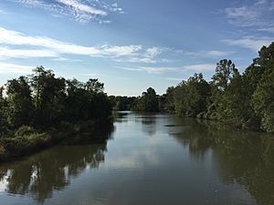
The Patuxent River forms the eastern boundary of Croom
|
|
| Country | |
| State | |
| County | |
| Area | |
| • Total | 35.41 sq mi (91.70 km2) |
| • Land | 34.19 sq mi (88.56 km2) |
| • Water | 1.21 sq mi (3.14 km2) |
| Population
(2020)
|
|
| • Total | 2,720 |
| • Density | 79.55/sq mi (30.71/km2) |
| Time zone | UTC−5 (Eastern (EST)) |
| • Summer (DST) | UTC−4 (EDT) |
| FIPS code | 24-20925 |
| GNIS feature ID | 597296 |
Croom is a small community in Southern Prince George's County, Maryland, United States. It is called an "unincorporated community" because it doesn't have its own local government like a city or town. It's also a "census-designated place," which means the U.S. Census Bureau counts it as a specific area for statistics.
In 2020, about 2,720 people lived in Croom. This area used to have many tobacco farms and forests. Now, many of these areas have become neighborhoods for people who work in nearby Washington, D.C.. A big part of the Patuxent River Park, known as the Jug Bay Natural Area, is located in Croom.
Contents
History of Croom
How Croom Got Its Name
The land that is now Croom was first claimed in 1671 by a person named Christopher Rousby. He named it Croome after a manor (a large country house with land) in England, near a place called Sledmere.
Croom During the War of 1812
In August 1814, during the War of 1812, British soldiers marched through Croom. They were on their way to attack and burn parts of Washington, D.C..
Historic Buildings in Croom
Croom is home to several old and important buildings. Many of these are listed on the National Register of Historic Places (NRHP). This list includes places that are important to the history of the United States.
One of these is St. Thomas' Episcopal Church, which was built a long time ago, during colonial times. It was added to the NRHP in 2000. Other historic places in Croom on the NRHP are:
- John W. Coffren House and Store
- Bellefields
- Brookefield of the Berrys
- Mattaponi (John Bowie Jr. House)
- St. Thomas' Episcopal Parish Historic District
- Waverly
Columbia Air Center
From 1941 to 1956, the Columbia Air Center was located in Croom. This airport was very special because it was one of the first airports in the United States owned by African Americans.
Geography of Croom
Croom covers a total area of about 91.7 square kilometers (about 35.4 square miles). Most of this area, about 88.6 square kilometers (34.2 square miles), is land. The rest, about 3.1 square kilometers (1.2 square miles), is water.
Population of Croom
| Historical population | |||
|---|---|---|---|
| Census | Pop. | %± | |
| 2010 | 2,631 | — | |
| 2020 | 2,720 | 3.4% | |
| U.S. Decennial Census 2010 2020 |
|||
People Living in Croom (2020 Census)
The United States Census Bureau collects information about the people living in different places. Here's a look at the different groups of people who lived in Croom in 2020:
| Race / Ethnicity (NH = Not Hispanic) | Pop 2010 | Pop 2020 | % 2010 | % 2020 |
|---|---|---|---|---|
| White alone (NH) | 1,321 | 1,089 | 50.21% | 40.04% |
| Black or African American alone (NH) | 1,068 | 1,126 | 40.59% | 41.40% |
| Native American or Alaska Native alone (NH) | 16 | 11 | 0.61% | 0.40% |
| Asian alone (NH) | 35 | 30 | 1.33% | 1.10% |
| Pacific Islander alone (NH) | 1 | 1 | 0.04% | 0.04% |
| Some Other Race alone (NH) | 16 | 29 | 0.61% | 1.07% |
| Mixed Race or Multi-Racial (NH) | 64 | 160 | 2.43% | 5.88% |
| Hispanic or Latino (any race) | 110 | 274 | 4.18% | 10.07% |
| Total | 2,631 | 2,720 | 100.00% | 100.00% |
Education in Croom
Public schools in Croom are managed by Prince George's County Public Schools.
Elementary Schools
Children in Croom attend one of these elementary schools:
- Baden Elementary
- Brandywine Elementary
- Marlton Elementary
- Mattaponi Elementary
- Patuxent Elementary
Middle Schools
Most students in Croom go to Gwynn Park Middle School. Some areas are zoned for James Madison Middle School or Kettering Middle School.
High Schools
Most high school students in Croom attend Frederick Douglass High School, which is located in Croom. Other students might go to Dr. Henry A Wise, Jr. High School or Gwynn Park High School, depending on where they live.
Notable People from Croom
Some famous people have connections to Croom:
- William Duckett Bowie (1803–1873): A politician.
- Robert Bowie (1750–1818): Served as the governor of Maryland.
- William Williams (c. 1793–1814): An escaped slave who joined the army (38th United States Colored Infantry Regiment). He sadly died from injuries after the British attacked Fort McHenry during the War of 1812.
See also
 In Spanish: Croom para niños
 | Georgia Louise Harris Brown |
 | Julian Abele |
 | Norma Merrick Sklarek |
 | William Sidney Pittman |


